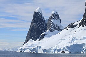
Cape Renard
| Cape Renard | ||
 Cape Renard with the Una Peaks |
||
| Geographical location | ||
|
|
||
| Coordinates | 65 ° 1 ′ S , 63 ° 46 ′ W | |
| location | Renard Island , West Antarctica | |
| coast | Danco and Graham coast | |
| Waters | Bay of Flanders | |
| Waters 2 | Butler passage | |
Cape Renard ( French: Cap Renard ) is a prominent point of land , which is dominated by two up to 740 m high rock needles , the Una Peaks . Their flanks are so steep that no snow sticks to them. The on the island Renard Iceland situated Cape marks the entrance to the south-west Flanders Bay and shares on the west side of the Antarctic Peninsula , the Danco Coast of the Graham Coast .
It was discovered by the Belgica expedition (1897–1899) led by the Belgian polar explorer Adrien de Gerlache de Gomery . He named the cape after the Belgian mineralogist Alphonse-François Renard (1842–1903), a member of the expedition commission.
Web links
- Cape Renard in the Geographic Names Information System of the United States Geological Survey (English)
- Cape Renard on geographic.org (English)
