
Karimabad (Hunza)
| Karimabad | |||
| State : |
|
||
| Province : | Gilgit-Baltistan | ||
| Coordinates : |
36 ° 20 ′ N , 74 ° 40 ′ E
|
||
| Height : |
2450 m
|
||
| Residents : | 7,000 | ||
| Time zone : |
PST ( UTC + 5 )
|
||
|
|||

Karimabad or Baltit is a city in Pakistan .
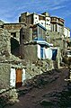
The mud houses of the small town are located above the Karakoram Highway on the steep face of the Ultar Sar .
The city was named after Prince Karim Aga Khan , the spiritual leader of the Shia - Ismailite - Nizarite community. It was the capital of Hunza until 1974 when the state became part of the northern areas of Pakistan. Since 2009 the northern areas have been called Gilgit-Baltistan . The Gilgit district , to which Karimabad belonged until then, was divided into Gilgit and Hunza-Nagar . Karimabad is now in the Hunza-Nagar district. Fort Baltit
rises above the city . Two kilometers to the east stands the older Altit fortress on a ledge .
Wheat, maize and fruit are harvested in the fields and gardens, which are very small due to lack of space, and are laid out in terraces. The apricots from Hunza, which are a particularly important food in summer and are dried on the roofs for the long winter, are well known.
During the summer, Karimabad is visited by tourists. From the city there are views of the mountain landscape with seven thousand meter peaks such as the Rakaposhi .

View of the roofs of Karimabad
Karimabad under Fort Baltit

View from Baltit to Fort Altit

View from Baltit to the Rakaposhi

View from the city into the Hunza Valley


