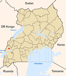
Kasese
| map | |
|---|---|

Location of Kasese within Uganda |
|
| Basic data | |
| District | Kasese |
| Geographical location | 0 ° 11 ′ N , 30 ° 5 ′ E |
| surface | ? |
| population | 67,279 (2005 estimate) |
| Population density | ? Inhabitants / km² |
| medium height | 1006 m |
| Precipitation | 970 (?) Mm / a |
| Time zone | UTC +3 |
| UN / LOCODE | UG KSE |
| Telephone code | (+256) 0483 |
Kasese is a city in southwest Uganda with about 67,279 inhabitants. It is the capital of the Kasese district of the same name . The place is on the eastern edge of the Ruwenzori Mountains and on the northwestern edge of the Queen Elizabeth National Park .
Copper mining was significant until the 1970s . Today cobalt is still extracted from the overburden of the copper mines . Kasese is the terminus of a rail connection to Kampala , which was recently limited to freight traffic and has since been dismantled. There is also a small airfield.
From 1997 to 2001 the struggle of the rebels of the Allied Democratic Forces flared up again around Kasese , which displaced several thousand residents of the surrounding areas. Since the returned already in 2007 to Kasese King Mumbere was officially recognized by the Government of Uganda on 19 October 2009 and Kasese now part of the ancient kingdom again Rwenzururu is applicable for also composing from parts of the Bakonjo population ADF motivation to armed struggle.
Population development
| year | Residents |
|---|---|
| 1991 census | 18,750 |
| 2002 census | 53,907 |
| 2005 estimate | 67.279 |