Kaslo
| Kaslo | ||
|---|---|---|
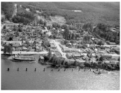
 Kaslo, around 1946 |
||
| Location in British Columbia | ||
|
|
||
| State : |
|
|
| Province : | British Columbia | |
| Regional District : | Central Kootenay | |
| Coordinates : | 49 ° 55 ′ N , 116 ° 54 ′ W | |
| Area : | 3.01 km² | |
| Residents : | 968 (as of 2016) | |
| Population density : | 321.6 inhabitants / km² | |
| Time zone : | Mountain Time ( UTC − 7 ) | |
Kaslo is a village in the southeast of the Canadian province of British Columbia . The community is located on Kootenay Lake and is part of the Regional District of Central Kootenay . The place originated at the confluence of the Kaslo River in the Kootenay Lake and is one of the larger settlements on the lake.
history
Before the arrival of European settlers, the area was the settlement area of the First Nations , here the Ktunaxa .
The local history of today's municipality is closely linked to the regional silver finds at the end of the 19th century. The granting of local self-government for the community took place on August 14, 1893 ( incorporated ). It is the oldest municipality in the region. Kaslo has had its current status ( Village ) since March 3, 1961 .
When Japanese and Canadians of Japanese descent were interned during World War II , Kaslo was one of the locations selected for this in 1941.
National Historic Site of Canada
The community is home to two National Historic Sites of Canada . On November 7, 1958, the SS Moyie , a paddle steamer of the late 19th century, was declared a monument. The town hall, the Kaslo Municipal Hall , built in 1898 , was declared a monument on November 23, 1984 as the oldest remaining town hall.
Demographics
The census in 2016 showed a population of 968 inhabitants for the municipality, after the census in 2011 showed a population of 1026 inhabitants for the municipality. The population decreased by 6.1% compared to the last census in 2011, while the population in the province of British Columbia increased by 5.6% at the same time. In the census period from 2006 to 2011, too, the population had already decreased by 4.3%, contrary to the trend at the time in the province with an increase of 7.0%.
For the 2016 census, a median age of 56.0 years was determined for the municipality . The median age of the province in 2016 was only 43.0 years. The median age was 49.6 years, or 42.3 years in the province. For the 2011 census, a median age of 49.9 years was determined for the municipality. The median age of the province in 2011 was only 41.9 years. The municipality is not only shrinking against the provincial average, but the remaining inhabitants are also on average significantly older than in the rest of the province.
traffic
Highway 31 runs through Kaslo . In addition, this is the end point of Highway 31A , which connects the place with New Denver on Slocan Lake .
To the west of the municipality is the local airport ( IATA airport code : -, ICAO code : -, Transport Canada Identifier: CBR2). The airfield has only a short asphalt runway 1,170 meters long.
Web links
Individual evidence
- ^ Origin Notes and History. Kaslo. GeoBC , accessed July 15, 2019 .
- ^ SS Moyie National Historic Site of Canada. In: Canadian Register of Historic Places. Retrieved July 15, 2019 .
- ^ Kaslo Municipal Hall National Historic Site of Canada. In: Canadian Register of Historic Places. Retrieved July 15, 2019 .
- ↑ Kaslo Community Profile. Census 2016. In: Statistics Canada . June 21, 2019, accessed July 15, 2019 .
- ↑ Kaslo Community Profile. Census 2011. In: Statistics Canada . May 31, 2016, accessed July 15, 2019 .
