
Kerasona
|
Local community Kerasona Τοπική Κοινότητα Κερασώνος (Κερασώνα) |
|||
|---|---|---|---|
|
|||
| Basic data | |||
| Country |
|
||
| region | Epirus | ||
| Regional district | Preveza | ||
| local community | Ziros | ||
| Parish | Filippiada | ||
| Geographic coordinates | 39 ° 18 ' N , 20 ° 53' E | ||
| Height above d. M. |
165 m average |
||
| surface | 13.649 km² | ||
| Residents | 283 (2011) | ||
| LAU-1 code no. | 21020105 | ||
| Local division | 2 | ||

Kerasona ( Greek Κερασώνα ( f. Sg. )) Is a village in the Filippiada district of the Greek municipality of Ziros in the south of the Epirus region .
The village is located in the Lourostal on the national road 5 and together with the place Agia Faneromeni forms the local community Kerasona (gr. Topiki Kinotita Kerasonos Τοπική Κοινότητα Κερασώνος) with 283 inhabitants.
Church in Kerasona

National Road 5 through the village of Kerasona

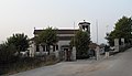
Kerasona village primary school


Infrastructure
Kerasona has a primary school and there is a secondary school in Filippiada.
Sports
AO Kerasona football club offers sporting activities in the village of Kerasona.
Individual evidence
- ↑ Results of the 2011 census at the National Statistical Service of Greece (ΕΛ.ΣΤΑΤ) ( Memento from June 27, 2015 in the Internet Archive ) (Excel document, 2.6 MB)