
Khardaha
| Khardaha | |||
|---|---|---|---|
|
|||
| State : |
|
||
| State : | West Bengal | ||
| District : | Uttar 24 Pargana | ||
| Location : | 22 ° 43 ' N , 88 ° 23' E | ||
| Height : | 15 m | ||
| Residents : | 108,496 (2011) | ||
 |
|||

Khardaha , also Khardah , is a city in the Indian state of West Bengal . The city is part of the Kolkata agglomeration .
The city belongs to the district of Uttar 24 Pargana . Khardaha has the status of a municipality . The city is divided into 23 wards (constituencies).
history
Originally, Khardah was part of the South Barakpur and West Barakpur parishes founded in 1877 . The South Barakpur community was renamed Khardah in 1920.
Demographics
The city's population is 108,496 according to the 2011 census. Khardaha has a gender ratio of 977 women per 1000 men and thus a male surplus typical for India. The literacy rate was 94.4% in 2011. Almost 91% of the population are Hindus , around 9% are Muslims and less than 1% belong to another or no religion. 6.8% of the population are children under 6 years of age. Bengali is the main language in and around the city.
Infrastructure
Downtown Kolkata is accessible from Khardaha Railway Station. The Barrackpore Trunk Road, which connects Kolkata with Barakpur , runs through the city.
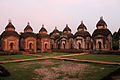
Attractions
26 Shiva temples were built here on the banks of the Ganges at the beginning of the 19th century .
gallery

Khardaha Railway Station

college
Shiva temple
.jpg)


Individual evidence
- ↑ www.census2011.co.in
- ↑ Khardaha City Population Census 2011-2019 | West Bengal. Retrieved September 26, 2019 .