Killiniq Island
| Killiniq Island | ||
|---|---|---|
| Waters | Labrador Sea | |
| Geographical location | 60 ° 24 ′ N , 64 ° 37 ′ W | |
|
|
||
| length | 30 km | |
| width | 11 km | |
| surface | 269 km² | |
| Highest elevation | Mont Qalirusilik 580 m |
|
| Residents | uninhabited | |
| main place | (Port Burwell) | |
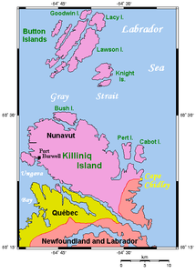
| Map of Killiniq and surroundings | ||
Killiniq Island (often also referred to as Killinek Island ) is an island in northern Canada in front of the northeast tip of Labrador . It is the only landmass in Canada where the territory of Nunavut ( Qikiqtaaluk region ) and the province of Newfoundland and Labrador share a land border.
history
The rich hunting and fishing grounds around the island have been used by Inuit for centuries. In the 1960s, a trading and weather station and a base of the Royal Canadian Mounted Police with appropriate infrastructure were built on the site of the Inuit settlement . Because of the terrain, it was not possible to build an airfield near the settlement, which made it difficult to supply the base. When the population declined in the late 1970s, the government decided to abandon the settlement. As a result, the Inuit families were also relocated to distant locations in Nunavik and Nunavut against their will . They had to leave equipment and supplies behind and lost their familiar surroundings.
In the first few years after the settlement was abandoned, there were only sporadic visits by Inuit to Killiniq. In 1983 Makivik carried out an experimental fishing project with some original Inuit families from Killiniq, which ran until 1985. During this time part of the building infrastructure was moved to the mainland of Labrador (the place was called Tarpangayuq ), where attempts were made to establish an independent Inuit settlement and where some Inuit families wintered in 1985/86.
Until the early 1990s, the Canadian Coast Guard used some of the buildings and facilities as a weather station during the summer months. But then a new, unmanned station was built right next to the previous settlement.
geography
Killiniq Island is located off the northeast tip of the Labrador Peninsula and is separated from it by the McLelan Strait , which is only a few hundred meters (150 meters at its narrowest point) wide . In the west the island is bordered by the Ungava Bay , in the east by the Labrador Sea and in the north by the Gray Strait , which separates Killiniq Island from the Button Islands . The island is 30 km long, up to 11 km wide and has an area of 269 km². The 10 km long border between the Nunavut Territory and the Newfoundland and Labrador Province is in the southeast of the island.
On the west coast of Killiniq, in what is now Nunavut, Port Burwell was a settlement and an outpost of the Royal Canadian Mounted Police until 1978 .
- Views
Web links
- Private side with pictures of Killiniq Iceland (English)
- An environmental report on Killiniq / Port Burwell (PDF; English; 4.0 MB)


