Qikiqtaaluk
| Qikiqtaaluk region | |
|---|---|
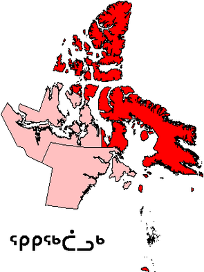
 Location of the region in Nunavut
|
|
| Basic data | |
| Country | Canada |
| territory |
Nunavut
|
| Administrative headquarters | Iqaluit |
| Coordinates : | 70 ° 0 ′ N , 80 ° 0 ′ W |
| Residents | 18,988 (as of 2016) |
| surface | 443,277.47 km² |
| Population density | 0 inhabitants / km² |
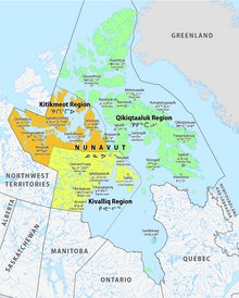
Qikiqtaaluk Region , Qikiqtani Region ( Inuktitut ᕿ ᑭ ᖅ ᑖ ᓗ ᒃ ) or Baffin Region is an administrative region of the Canadian Nunavut Territory . Qikiqtaaluk is the traditional name in the Inuktitut language for Baffin Island . Qikiqtaaluk Region is the most common name in official contexts. Although the name Qikiqtaaluk has been official since 1999, Statistics Canada continues to refer to the area as "Baffin Region, Nunavut" in publications such as the Census . The regional administrative center is Iqaluit (population 7,740).
The region consists of Baffin Island, the Belcher Islands , the Ottawa Islands , Akimiski Island , Mansel Island , Prince Charles Island , the Bylot Island , Devon Island , Cornwallis Island , Bathurst Island , Amund Ringnes Island , Ellef Ringnes Island , Axel Heiberg Island , Ellesmere Island , the Melville Peninsula , the eastern part of the Simpson Peninsula and Melville Island and the northern part of the Prince of Wales Island and Somerset Island and smaller islands such as Vivian Island in between. The region includes both the northernmost (Ellesmere Island) and southernmost areas (Akimiski Island) of the territory. In addition, according to the Canadian view, the Hans Island also belongs to this region. However, Denmark , which represents the autonomous Greenland in foreign affairs, also claims the island.
Prior to 1999, the Qikiqtaaluk Region existed under slightly different boundaries than Baffin Region, Northwest Territories.
Demographics
| census | region | Nunavut | ||
|---|---|---|---|---|
| Residents | Change in% |
Residents | Change in% |
|
| 2016 | 18,988 | + 12.1 | 35,944 | + 12.7 |
| 2011 | 16,939 | + 7.4 | 29,474 | + 8.3 |
| 2006 | 15,765 | + 9.7 | 29,474 | + 10.2 |
| 2001 | 14,372 | + 8.7 | 26,745 | + 8.1 |
| 1996 | 13,218 | + 16.1 | 24,730 | |
| 1991 | 11,385 | |||
Communities
The region is divided into 14 municipalities. However, 99.84 percent of the area does not belong to any municipality.
- Iqaluit (capital, formerly Frobisher Bay)
- Arctic Bay
- Cape Dorset
- Clyde River
- Grise Fiord
- Hall Beach
- Igloo
- Kimmirut
- Nanisivik
- Pangnirtation
- Pond inlet
- Qikiqtarjuaq
- Resolute
- Sanikiluaq
Eight parishes are on Baffin Island (with offshore islands), two on the Queen Elizabeth Islands in the far north, two on the Melville Peninsula (including offshore islands) and one on the Belcher Islands in the south.
Rest of the area
The following stations, trading posts and camps, which have now largely been abandoned or abandoned, are located outside the municipalities:
- Achiwapaschikisit
- Alert
- Alexandra Fiord
- Amadjuak
- Aquiatulavik Point
- Cape Dyer
- Cape Smith
- Charlton Depot
- Craig Harbor
- Dundas Harbor
- Eureka
- Fort Conger
- Hazen Camp
- Isachsen
- Kekerten
- Killiniq
- Kipisa
- Kivitoo
- Mikwasiskwaw Umitukap Aytakunich
- Nottingham Island
- Nuwata
- Padloping Island
- Polaris
- Port Burwell
- Resolution Island
- Tanquary Camp
- Tupialuviniq
- Ward Hunt Island Camp
Protected areas
- Auyuittuq National Park
- Sirmilik National Park
- Quttinirpaaq National Park
- Iqalugaarjuup Nunanga Territorial Park
- Katannilik Territorial Park Reserve
- Kekerten Territorial Park
- Kugluk / Bloody Falls Territorial Park
- Mallikjuaq Territorial Park
- Northwest Passage Territorial Park
- Ovayok Territorial Park
- Qaummaarviit Territorial Park
- Sylvia Grinnell Territorial Park
Individual evidence
- ^ Census Profile, 2016 Census. In: Statistics Canada . February 9, 2017, accessed August 11, 2020 .
- ^ Census Profile, 2016 Census. Subprovincial geography levels: Nunavut. In: Statistics Canada . February 9, 2017, accessed August 11, 2020 .
- ^ Census Profile, 2011 Census. Subprovincial geography levels: Nunavut. In: Statistics Canada . November 27, 2015, accessed on August 11, 2020 .
- ↑ 2006 Community Profiles. In: Statistics Canada . August 21, 2019, accessed on August 11, 2020 .
- ↑ 2001 Community Profiles. In: Statistics Canada . July 2, 2019, accessed on August 11, 2020 .
- ^ Profile of Census Divisions and Subdivisions, 1996 Census. In: Statistics Canada . December 23, 2013, accessed on August 11, 2020 .
- ↑ - baffin, Unorganized: Place name (s). Statcan

