Kitikmeot
| Kitikmeot region | |
|---|---|
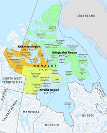
 Location of the region in Nunavut
|
|
| Basic data | |
| Country | Canada |
| territory |
Nunavut
|
| Administrative headquarters | Cambridge Bay |
| Coordinates : | 68 ° 55 ′ N , 100 ° 45 ′ W |
| Residents | 6,543 (as of 2016) |
| surface | 443,277.47 km² |
| Population density | 0 inhabitants / km² |
Kitikmeot Region ( Inuktitut : Qitirmiut ᕿᑎᕐᒥᐅᑦ) is one of the three administrative regions of the Canadian Nunavut Territory . It consists of the southern and eastern parts of Victoria Island and the opposite mainland. It includes the Boothia Peninsula , King William Island , Berens Islands and the southern part of Prince of Wales Island .
The administrative seat is Cambridge Bay , which has 1,766 residents .
Prior to 1999, the Kitikmeot Region existed with slightly different boundaries as part of the Mackenzie District of the Northwest Territories .
Communities
| local community | Inuktitut | Inuktitut syllabary |
Area ( km² ) |
Population (2016 census) |
|---|---|---|---|---|
| Bathurst Inlet | Qingguak | ᕿᙵᐅᓐ | 19.10 | 0 |
| Bay Chimo Harbor | Umingmaktuk | 100.29 | 0 | |
| Cambridge Bay | Iqaluktuuttiaq | ᐃᖃᓗᒃᑑᑦᑎᐊᖅ | 202.35 | 1,766 |
| Gjoa Haven | Uqsuqtuuq | ᐅᖅᓱᖅᑑᖅ | 28.47 | 1,324 |
| Kugaaruk | Kuugaarjuk | ᑰᒑᕐᔪᒃ | 4.97 | 933 |
| Kugluktuk | Qurluktuk | ᖁᕐᓗᖅᑐᖅ | 549.65 | 1,491 |
| Taloyoak | ᑕᓗᕐᔪᐊᖅ | 37.65 | 1,029 | |
| unorganized | 442334.99 | 0 | ||
| Kitikmeot | Qitirmiut | ᕿᑎᕐᒥᐅᑦ | 443277.47 | 6,543 |
Demographics
| census | region | Nunavut | ||
|---|---|---|---|---|
| Residents | Change in% |
Residents | Change in% |
|
| 2016 | 6,543 | + 8.8 | 35,944 | + 12.7 |
| 2011 | 6.012 | + 12.1 | 29,474 | + 8.3 |
| 2006 | 5,361 | + 11.3 | 29,474 | + 10.2 |
| 2001 | 4,816 | + 3.7 | 26,745 | + 8.1 |
| 1996 | 4,644 | + 15.4 | 24,730 | |
| 1991 | 4,386 | |||
Protected areas
- Ovayok Territorial Park
- North West Passage Territorial Park
- Kugluk / Bloody Falls Territorial Park
- Queen Maud Gulf Bird Sanctuary
Web links
- Kitikmeot Region information at Explore Nunavut
- Kitikmeot Heritage Society
-
Kitikmeot Inuit Association
- Kitikmeot Corporation , economic development
- Kitikmeot Economic Development Commission , education and training
- Kitikmeot School Operations
- Kitikmeot information
Individual evidence
- ^ Census Profile, 2016 Census. Subprovincial geography levels: Nunavut. In: Statistics Canada . February 9, 2017, accessed August 7, 2020 .
- ^ Census Profile, 2011 Census. Subprovincial geography levels: Nunavut. In: Statistics Canada . November 27, 2015, accessed on August 11, 2020 .
- ↑ 2006 Community Profiles. In: Statistics Canada . August 21, 2019, accessed on August 11, 2020 .
- ↑ 2001 Community Profiles. In: Statistics Canada . July 2, 2019, accessed on August 11, 2020 .
- ^ Profile of Census Divisions and Subdivisions, 1996 Census. In: Statistics Canada . December 23, 2013, accessed on August 11, 2020 .
