Cambridge Bay
| Cambridge Bay | ||
|---|---|---|
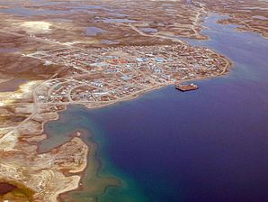
 Aerial view of Cambridge Bay |
||
| Location in Nunavut | ||
|
|
||
| State : |
|
|
| Territory : | Nunavut | |
| Region: | Kitikmeot | |
| Coordinates : | 69 ° 7 ′ N , 105 ° 3 ′ W | |
| Area : | 202.35 km² | |
| Residents : | 1766 (as of 2016) | |
| Population density : | 8.7 inhabitants / km² | |
 Inuit settlement Cambridge Bay |
||
Cambridge Bay ( Inuinnaqtun : Iqaluktuuttiaq Syllabics : ᐃᖃᓗᒃᑑᑦᑎᐊᖅ) is a settlement in the southern part of the Arctic Victoria Island on the Dease Strait ( Northwest Passage ) with over 1,700 inhabitants (around 80% of them Inuit) and the regional center of the Kitikmeot region . Her Inuinnaqtun name means "good place for fishing".
Surname
The bay was named after a Hudson's Bay Company expedition team that mapped the north coast of mainland Canada in 1839. It was named after Adolphus Frederick, 1st Duke of Cambridge , who was the British King's deputy in the Kingdom of Hanover until 1837 .
history

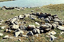
For centuries, the area around what is now Cambridge Bay was a summer meeting place for families of the "Copper Eskimos", so called after copper tools that they made from natural deposits of this metal on Victoria Island.
In 1927 the Hudson's Bay Company established a trading post here, after the Canadian police had set up a post the previous year. Few Inuit lived around the bay until the 1950s. That changed, however, when a lighthouse was erected here in 1947 and a DEW-Line station (“Distant Early Warning Line”) began its service in 1955 . The settlement received the status of "hamlet" (municipality) on April 1, 1984.
languages
In addition to English, Innuinaqtun , an Inuktitut dialect, is spoken, which is usually written in Latin letters rather than the syllabary used for Inuktitut.
Attractions
On the opposite bank of Cambridge Bay are the remains of a stone church, which the Oblate Fathers built in 1954 on the original settlement site and abandoned after the settlement was relocated. The abandoned church, previously known as a landmark and tourist attraction, was burned on April 27, 2006. Today the ruin is also a sight, especially since the former fishing boat Eagle of the co-builder of the church, Father Steinman, is set up directly below the former church .

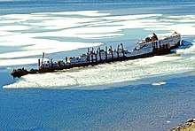
A historically significant sight has ceased to exist since 2016/17. The wreck of the Maud lay in the immediate vicinity of the settlement . The Norwegian Roald Amundsen undertook two research trips with this ship between 1918 and 1925. Taken over by the Hudson's Bay Company in 1926, it was then used as a supply ship until it sank in Cambridge Bay in 1930. After several unsuccessful attempts, the wreck was lifted for takeover by the Norwegian capital Oslo in early August 2016 and loaded onto a transport pontoon . The journey to Norway began in the summer of 2017, and the tow arrived in Greenland in September 2017 ; after wintering, Oslo should be reached in summer 2018.
tourism
Cambridge Bay is an ideal starting point for nature observation. With the van, the near and far surroundings can be reached relatively easily on gravel roads. B. the 290 meters above sea level. d. M. towering ridges of Mount Pelly (Uvajuq) in the Ovajok Territorial Park . A special attraction is the local fauna, which primarily includes musk ox and many ground-breeding birds.
Cambridge Bay is occasionally called at by cruise ships on their course through the Northwest Passage .
Infrastructure
West-southwest of the municipality is the local airfield ( IATA : YCB, ICAO : CYCB), which only has a gravel runway of 1,547 meters in length. Reachable is Cambridge Bay Airport with regional airlines (z. B. with First Air or Canadian North ) from Yellowknife or Gjoa Haven , Kugaaruk , Kugluktuk and Taloyoak . There is no connection to the rest of the territory or the other provinces by road, rail or regular passenger shipping.
The settlement has a health center and a number of school facilities (Elementary School, High School and Arctic College).
Two submarine cables are currently being built with Arctic Fiber and Ivaluk Network , which will have a landing point in Cambridge Bay.
literature
- Miriam Dewar (Ed.): The Nunavut Handbook: Traveling in Canada's Arctic . Ayaya Marketing & Communications, Iqaluit / Ottawa 2004, ISBN 0-9736754-0-3 (English).
Web links
Individual evidence
- ^ Census Profile, 2016 Census. In: Statistics Canada . February 9, 2017, accessed August 11, 2020 .


