
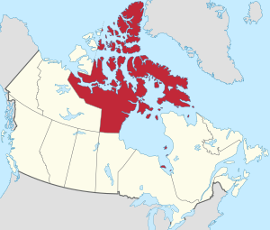
Nunavut
| coat of arms | flag |
|---|---|
 ( Details ) |
 ( Details ) |
|
Motto : Nunavut Sannginivut "Our country, our strength" |
|
| location | |
  |
|
| Basic data | |
| Official languages | Inuktitut , Inuinnaqtun , English and French |
| Capital | Iqaluit |
| Biggest town | Iqaluit |
| surface | 1,877,778.53 km² (1st) |
| Population (2016) | 35,944 |
| Population density | 0.02 inhabitants / km² |
| GDP in CAD (2007) | Total: 1.371 billion (11th) Per capita: 43,595 (8th) |
| Time zone | UTC −4 to −7 |
| ISO 3166-2 | CA-NU |
| Postal abbreviation | NU |
| Website | Nunavut government |
| politics | |
| Joined Confederation | April 1, 1999 |
| Commissioner | Nellie Kusugak |
| prime minister | Joe Savikataaq |
| Sit in the lower house | 1 |
| Seat in the Senate | 1 |
Nunavut (in the syllabary of the Inuit : ᓄᓇᕗᑦ, literally "Our country," actually "Our Homeland") is a territory in northern Canada with special rights for the Inuit living there. It is bordered to the west by the Northwest Territories , to the east by Greenland and to the south by the provinces of Manitoba , Ontario, and Québec . The capital is Iqaluit (former name - Frobisher Bay ), located on Canada's largest island, Baffin Island .
geography
Extension and Limits
The Nunavut Territory includes parts of mainland Canada, most of the Arctic Islands of Canada and all of the islands of Hudson Bay , James Bay and Ungava Bay , which were formerly part of the Northwest Territories. As a result, Nunavut with smaller territorial areas extends very far to the south - the southernmost island, Stag Island, is located at 51 ° 39′01 ″ N latitude, which is even a little further south than the German city of Paderborn .
Nunavut covers around two million square kilometers and thus covers about one fifth of the area of Canada. On the mainland, Nunavut is bordered by the Province of Manitoba to the south and the Northwest Territories to the west. On Vierländereck Four Corners territory also borders the province of Saskatchewan . Hudson Bay is also the southern border area - with the provinces of Manitoba, Ontario and Québec . There is also a border between Québec and Nunavut on Diana Island . In the northwest there is also a border between Nunavut and the Northwest Territories on the four islands of Victoria Island, Melville Island, King Island and Borden Island. In the south, on Killiniq Island at the northern tip of the Labrador Peninsula , Nunavut also has a border of only about ten kilometers with the province of Newfoundland and Labrador .
In the east of the Baffin Island , Devon Island and Ellesmere Island , which belong to Nunavut , the Canadian state border runs across from Greenland in the Davis Strait , Baffin Bay and Nares Strait . The uninhabited Hans Island is claimed by both Greenland and Canada and is now administered as a condominium .
Larger parts of Nunavut are designated as national parks. Trekking expeditions with local guides are registered with Parks Canada .
Geology and landscape structure
The geological structure plays an important role for Nunavut. On the Borden and Ellef Ringnes Islands there is a narrow arctic coastal plain, clearly separated from the hinterland.
The Arctic lowlands are connected to this level, extending to the south-east over the northern Canadian archipelago (especially Victoria Island , Prince of Wales Island , Somerset Island and the north-western part of Baffin Island ) , which is connected to the south by the Canadian Shield is limited. This Arctic lowland is dominated by flat sedimentary rocks from the older Paleozoic . It is relatively flat and descends from around 700 meters above sea level. M. in the north at about 100 meters above sea level. M. in the south.
.jpg)
In the west, on Victoria Island, the volcanically determined Shaler Mountains rise again to around 700 meters. In the northeast, where the coastal plain no longer continues, the mountainous region of the Innuitians rises ; it extends over all islands north of the Parry Channel or the Northwest Passage . The Innuitians, formed by folding in the Paleozoic and at more than 1000 meters above sea level. d. M. rising, form with the Queen Elizabeth Islands , i.e. with the Ellesmere Island , the Parry Islands and the Sverdrup Islands , the northern end of the Arctic Ocean . The highest point is Barbeau Peak in the northern part of Ellesmere Island with 2616 meters. The individual mountain peaks rise naked from the wide ice fields there as nunatakkers ("headland").
Generally speaking, the area north of the Arctic Circle, essentially the archipelago north of the mainland, is called the “High Arctic”.
.jpg)
Geologically, the Arctic landscape is still very young. Around 20,000 years ago, during the Pleistocene , northern Canada had reached a maximum of glaciation and, apart from a few ice-free retreats, was still completely covered with glaciers . With the end of the last ice age (around 8000 BC) the ice slowly receded; the northern regions became largely ice-free only a few millennia ago, and in some cases even a few centuries ago. In addition to the already harsh growth conditions, this is the main reason for the species poverty of the flora there .
As a result of the alternating thawing and freezing of the soil surface, loose stone material creates special frost patterns of various shapes, for example the so-called polygons . Other forms are formed by forcing up water, especially mounds of earth with ice cores; Among the strangest forms of this species are the pingos that occur on many high Arctic islands , whose conical hills can grow to over 50 meters high and 300 meters in diameter.
Climatic conditions
.jpg)
The amount of precipitation is extremely low. In the High Arctic, i.e. north of the Arctic Circle , there is only 200 mm or less precipitation per year, which is why this region is known as the “polar desert”. In the other parts of Nunavut and the Northwest Territories, 400 mm is hardly exceeded, only the area around Iqaluit on Baffin Island reaches 600 mm per year. In the Kivalliq region , snow depths of around 75 cm are measured in winter, but in parts of Baffin Island up to 200 cm .
Despite low rainfall, the Nunavut area and the Northwest Territories account for around nine percent of the world's freshwater resources.
During the long polar night, extremely low temperatures develop in the Arctic region, often around −50 ° C. Average January temperatures in Nunavut and the Northwest Territories are below −20 ° C.
In the transition period from April to mid-June, solar radiation increases, but up to 80% of the rays are reflected by the snow and are lost in the conversion into heat (effect of the albedo ). Only after the snow has melted or the snow has evaporated from cold does the soil's heat absorption capacity increase; In the short summer period from mid-June to August, the soil temperatures reach the positive range. Average July temperatures of +10 ° C are only exceeded in the southern part of Nunavut and the Northwest Territories.
In addition to the low temperatures, there are often strong winds. This means that body heat is dissipated much more quickly in humans and animals. This cold effect caused by wind, which is much lower than the measured temperature, is called wind chill : -12 ° C and a wind speed of 40 km / h, for example, have the same effect as a temperature of -34 ° C and can therefore lead to severe frostbite . In general, the wind chill factor is determined with the help of empirical value tables. During eight months of the year, cold air from the North Sea prevails in the Arctic, but in the other months too, sudden drops in temperature and additional cooling winds can be expected everywhere.
| Alert | ||||||||||||||||||||||||||||||||||||
|---|---|---|---|---|---|---|---|---|---|---|---|---|---|---|---|---|---|---|---|---|---|---|---|---|---|---|---|---|---|---|---|---|---|---|---|---|
| Climate diagram | ||||||||||||||||||||||||||||||||||||
| ||||||||||||||||||||||||||||||||||||
|
Average monthly temperatures for Alert
Source: missing
|
|||||||||||||||||||||||||||||||||||||||||||||||||||||||||||||||||||||||||||||||||||||||||||||||||||||||||||||||||||||||||||||||||||||||
| Iqaluit | ||||||||||||||||||||||||||||||||||||
|---|---|---|---|---|---|---|---|---|---|---|---|---|---|---|---|---|---|---|---|---|---|---|---|---|---|---|---|---|---|---|---|---|---|---|---|---|
| Climate diagram | ||||||||||||||||||||||||||||||||||||
| ||||||||||||||||||||||||||||||||||||
|
Average monthly temperatures for Iqaluit
Source: missing
|
|||||||||||||||||||||||||||||||||||||||||||||||||||||||||||||||||||||||||||||||||||||||||||||||||||||||||||||||||||||||||||||||||||||||
Permafrost
One factor affecting the entire infrastructure of the Arctic region is permafrost , one of the most notable consequences of the Arctic climate. This is understood to mean the permanent frozen ground, a distinction being made between discontinuous (gradually dissolving) and continuous permafrost (the third type still observed is sporadic permafrost). Continuous permafrost is spread over about three million square kilometers in Canada, discontinuous permafrost on a little over one million square kilometers. The permafrost has its origin in the last ice age; so it has existed for more than 10,000 years. The frozen subsoil on Melville Island, for example, extends to a depth of more than 500 meters. Low, because tangential, solar radiation in the summer months and extreme winter temperatures with little snow allow the soil to thaw only superficially during the short summer warming phase; in many places the thawing depth is at most 50 centimeters or a little more. As a result, permafrost has an impact on the structure of housing estates and their supply and disposal as well as on the economically important mining industry and, last but not least, on transport opportunities.
The southern boundaries of the continuous permafrost and the area known as the arctic climate zone, i.e. the area of treeless tundra, are largely congruent. They run from the northwest (near the Arctic coast) across today's Northwest Territories to the southeast to the south coast of Hudson Bay and from there to the northeast to the Atlantic Ocean (near the south coast of Baffin Island). As a result, Nunavut is almost exclusively covered by tundra. Only in the southwest on the border with the Northwest Territories is a smaller boreal zone ( taiga ).
fauna


For the people resident in the tundra areas, the animal world played a crucial role in the survival. Land and sea animals provided food, clothing and equipment. However, no animal species was threatened by the extinction by the natives of the Arctic; such a threat only arose as a result of the advance of "Qallunaat", ie the "whites from the south".
Caribou and musk ox have always been of particular importance to the Inuit ; partly that still applies today. The total number of caribou has decreased enormously in the course of the 20th century as a result of heavy hunting, increased occurrence of wolves and increasing forest fires, but not least due to increased economic and technical activities. If the number was estimated at over two million in the 1930s, 40 years later it was only a little over half a million.
The same applies to the musk ox: Because of excessive hunting - also by the Inuit - the animals were almost extinct, which is why a hunting ban became inevitable in 1917, which could only be carefully relaxed again in 1969; the current population is estimated at around 15,000 animals.
In addition to caribou and musk ox, polar bears , arctic wolves , wolverines , arctic foxes , arctic hares , lemmings and various types of squirrels live on the tundra . None of these animals were chosen as a territorial symbol; the Legislative Assembly elected rather than "animal of Nunavut" Canadian Husky ( Canadian Inuit Dog , "Inuit dog").
There are also huge flocks of birds, including the rarer gyrfalcons and peregrine falcons ; in the summer months around 80 bird species are likely to nest in the Arctic, mainly on Bylot Island ( Sirmilik National Park ).
There are only a few species of fish - mostly arctic char and lake trout . However, there is great abundance of fish in both lakes and rivers and in the coastal regions, where also many marine mammals - whales ( bowhead whales , beluga whales , narwhals ) and seal species ( bearded seals , ringed seals , Atlantic walruses ) - are to be found.
flora

Arctic climate, i.e. only three months of summers with relatively low temperatures and long winters with extreme cold and strong winds, plus considerable drought and permafrost, had a negative effect on the development of the soil. Mineral soils emerged almost exclusively on water-permeable slopes - so-called arctic brown soils with a low humus layer. On the plains, on the other hand, mainly flat-ground tundra soil has formed over frozen subsoil, on which the moisture accumulates in summer and contributes to the formation of mud. Rocky subsoil also emerges over large areas or eternal ice remains.
Under such conditions, only relatively species-poor vegetation could develop. The region west of Hudson Bay is therefore referred to as " Barrenlands ", barren wasteland. The extreme cold slows growth and decay; Certain arctic lichens only increase their diameter by about half a centimeter per century, and the bacteria necessary for decomposition are only very limited in the dry cold. The density and diversity of vegetation decreases from south to north. If on the southern mainland there are still colorful flowering plant communities, mainly made up of grasses , butterflies , saxifrages , dwarf willow plants and heather plants, there are only a few favorable locations for higher vegetation on Baffin Island and the other northern islands; Lichen and moss predominate. On south-facing slopes with mineral soils and early snowmelt, u. a. Dandelion , various saxifrage plants such as the opposed saxifrage ( flower of the Nunavut Territory ), as well as tragacanth , fleabane , white arum ( flower of the Northwest Territories ) and arctic poppy .
population
Demographics
The number of residents of Nunavut was exactly 31,906 in 2011 (just under 1 ‰ of the total Canadian population), of which around 25,000 were Inuit (around 85% of the Nunavut population and around 50% of all Canadian Inuit). By the 2016 census, the population had increased by 12.7% to 35,944. Nunavut has a land area of 1,877,778 km², about 20% of the area of Canada, and is about six times the size of Germany . With a population density of 0.02 people per square kilometer, Nunavut is one of the least populated regions on earth. Almost all residents of the territory live in 25 municipalities. The largest place is the capital Iqaluit with 7,740 inhabitants, the second largest place Rankin Inlet with 2,842 inhabitants. Twelve other municipalities have over 1000 inhabitants; three settlements ( Nanisivik , Umingmaktuk , Bathurst Inlet ) are currently abandoned.
Population development
- 26,745 - May 15, 2001 (census)
- 29,992 - July 1, 2005
- 29,474 - May 16, 2006 (census)
- 31,216 - April 1, 2007
- 31,906 - May 2, 2011 (census)
- 35,944 - May 10, 2016 (census)
Life expectancy, diseases, causes of death

Over 20% of the population of Nunavut live well below the national standard. The life expectancy for a newborn child is 68.5 years in Nunavut and 79.7 years in all of Canada (2002). Infant mortality has decreased significantly in recent decades, but is still around three times higher than the national average. The proportion of lung cancers is significantly higher, especially in women, than in the rest of Canada (around five times), and of respiratory diseases even around seven times. 60% of residents age twelve and older smoke (30% in all of Canada), and about 75% of women also smoke during pregnancy. Tuberculosis diseases are almost eight times more common (1990) than the national average, and sexually transmitted diseases are up to 20 times more common. Alcohol and drug abuse, violence in families and dependence on social welfare play a role in the everyday life of a large number of Inuit that should not be underestimated. The suicide rate is noticeably high ; for years it has been at least four times higher than in the rest of Canada: from 1986 to 1996 the rate averaged 77.9 per 100,000 inhabitants (Canada 13.2 per 100,000). The rate is particularly high in males between the ages of 15 and 29. In the first 16 months after Nunavut was founded, 34 residents took their own lives, 32 were male; in 2004 the suicide rate was even 85.7 per 100,000 (total Canada 22.7 per 100,000). The reasons for such high rates are still poorly understood; to be mentioned u. a. Escape from frustration or physical pain, but the feeling of personal failure is often added. The suicide rates and the above-average rates of physical violence and pregnancies in adolescence are explained by scientists as “sociocultural oppression”. However, no statistical information is available, only general reports from explorers (cf. Kirmayer et al.) On how the Inuit behaved in times before they lived in settlements or even before they came into closer contact with western civilization. It is hoped that the detailed questioning of "Elders" will provide information on this, although one has to rely on their memory, since no written records are available. Statistics Canada determined the following percentages of causes of death for 2009 in Nunavut: cancer - 26.5%, suicide - 13%, accident - 11.1%, heart disease - 6.8%, respiratory disease - 6.8%, other - 35.8%. This means that the suicide rate is around eight times the Canadian average.
towns and places
Only Iquluit is designated as a city, all other larger settlements have the status of a hamlet (Hamlet).
The ten largest settlements in Nunavut had the following population figures according to the Canadian census by Statistics Canada of 2016:
|
|
history
.jpg)
Nunavut was separated from the Northwest Territories on April 1, 1999 and has been an independent territory since then. Although it is part of the Canadian state and, as a territory, directly assigned to the Canadian federal government, the founding of Nunavut was based on the idea of giving the Inuit the ability to administer this area relatively autonomously.
Originally, the Canadian authorities managed the north of the country with arrogant and often rude methods, albeit in keeping with the zeitgeist of the time, like a colonial area, and when attempting to integrate the Inuit into a modern Canada, they took little or nothing into account of the Inuit's essential cultural concerns was. In the 1950s to 1970s, numerous children were taken to boarding schools without their parents' permission and only came home during the summer holidays. They were alienated from Inuit culture, some were ill-treated or sexually abused, and many suffered from poor diet, housing and poor health care. The psychological consequences of this alienation from home and family continue to have an effect today. In 2008, Prime Minister Harper apologized to the Inuit and other affected Native Canadians for the practice.
In the 1970s, the Canadian government entered into lengthy negotiations with representatives of the Inuit, which finally led to the division of the Northwest Territories as a result of a plebiscite on April 14, 1982. Further details on the prehistory can be found under the keywords Inuit and Inuit culture .
Current situation in Nunavut Territory:


The Canadian Inuit, born up to the middle of the 20th century, were almost all born in camps - during winter in birthing igloos , in summer in specially built tents . The everyday life determined by the hunting conditions (occurrence of fish and huntable animals) was partly nomadic, partly camp-related. Today's way of life, determined by western influences, with supermarkets and television around the clock, was still unknown. A change came when compulsory education and not least the lack of wild game , connected with many advantages modern life in urban areas (heating, electricity, water, etc.), the Inuit led to abandon the pure camp life and the prefabricated from the south to pull established settlements. However, every opportunity was and is still used to spend free time outside on the land ("on the land") in a traditional style, but also using all modern technology such as radios , motorized vehicles, gas cookers, etc. Fax machines and e-mails , digital cameras , and surfing the Internet were gaining ground more quickly in Nunavut than in Central Europe .
The Canadian federal government recognized at an early stage that job creation measures with appropriate income opportunities had to be found for the indigenous people of the north who had previously lived exclusively from hunting (with barter trade). For example, there was widespread support in the Inuit art sector after the unusual artistic talent of many people who used to work as hunters was recognized. With the establishment of administrative structures in a modern industrial state, many jobs were also created, which, however, initially had to be filled with "Qallunaat" (non-Inuit) instead of Inuit due to a lack of specialist knowledge. In the meantime, especially since the establishment of the Nunavut Territory, significant changes have been made here, and the territorial government is judged not least by the success it has achieved in creating and filling Inuit jobs, because over a quarter of the population are still living Inuit in Nunavut from welfare. The economy in a highly developed welfare state (Canada) and the arrival of modern technology changed the lives of the Inuit in extreme ways, and many have not yet fully understood the rapid transition from traditional life in the country to existence in a modern state. They perceive it as “life between two worlds”.
While the birth and death rates , especially the infant mortality rate , were very high before the transition to settlement life , this has changed fundamentally due to the greatly improved medical care. Nunavut has a completely different age structure than the rest of the country. With the creation of Nunavut, the country's economy was faced with the challenge, with few paid jobs, a low level of education and a high proportion of young people (1996: around 60% of the population under 25 compared to the Canadian level of 34 %) To finish. The 2001 survey says: The mean age of the Inuit is extremely low at 20.6 years, about 17 years among non-Native Canadians (37.7 years). 39% of the Inuit population are 14 years old and younger (Non-Native Canadians 19%), 40% between the ages of 25 and 64 (Non-Native Canadians 55%). The number of those aged 65 and over grew by 38% to 3% between 1996 and 2001 (non-Native Canadians by 10% to around 12%). 73% of 14 year olds and younger lived with two parents (non-Native of Canada 83%), 25% with one parent (non-Native of Canada 17%), and 2% with other relatives or non-relatives. The latter figures do not include the relatively high adoption rate among the Inuit.
Both the rapid population growth and the changing age structure have major economic and social consequences. The creation of jobs, housing and educational facilities, the optimization of the infrastructure and the further improvement of social facilities (e.g. day care centers and retirement homes ) are challenges that the Nunavut government still has to face. Although many measures since the 1950s and 1960s have made life easier, which have long been common in the rest of Canada, many Inuit found themselves in a completely new social dependency on state institutions. Hunting, for example, used to be associated with long tours, but these are now undertaken with modern travel equipment ( quad (ATV), motorboat , snowmobile ), which are expensive to buy and maintain. There are still too few jobs available. In addition, many Inuit jobs are not very demanding and correspondingly low paid, depending on their qualifications. Unemployment and insufficient qualifications for higher-quality tasks are still the main problems facing Nunavut at the moment, which is why qualification measures are at the forefront of the government program. Skilled trades are so far unknown; Recently, however, training in shortage occupations such as nurses has been greatly promoted . Quite a few Inuit, especially the mayors elected in their respective communities, earn additional income as part-time volunteer reservists in the Canadian Rangers Regiment .
Political structure


Head of Nunavut and representative of the Canadian federal government (and thus indirectly the Canadian Queen Elizabeth II ) is a commissioner who is appointed by the Canadian government for five years. The office is primarily representative. The incumbent is currently Nellie Kusugak .
The territorial government is made up of a Prime Minister (currently Paul Quassa ) and eight other ministers. They are elected in a secret ballot by a total of 19 members of the 28 municipalities in the Nunavut territory from among their own ranks. The MPs also elect the Speaker of Parliament from among their number.
The elections to the House of Representatives took place every five years up to and including 2013 (1999, 2004, 2008 and 2013). Due to legal regulations, the elections are currently held every four years (starting in 2017). The MPs are not elected as representatives of political parties, but as individuals. Votes in parliament are based on the principle of majority voting. In general, the parliamentary sessions take place in the Legislative Building in the capital Iqaluit; However, in order to be closer to the people, it meets once a year outside the capital in a different municipality.
The so-called elders ("elders" of parishes) play a special role as advisors in matters of tradition, and for their presence in the parliamentary hall, seats decorated with seal skins have been installed.
Administrative division
In order to obtain an administrative structure corresponding to its spatial size, Nunavut was divided into the regional centers Iqaluit , Cambridge Bay and Rankin Inlet as well as the following three associated administrative regions:
- Qikiqtaaluk (formerly Baffin) with the main town Iqaluit (formerly Frobisher Bay) and the settlements Arctic Bay , Cape Dorset , Clyde River , Grise Fiord , Hall Beach , Iglulik , Kimmirut , Nanisivik , Pangnirtung , Pond Inlet , Qikiilqtarjuaq , Resolute. , Sanikiluaquaq .
- Kitikmeot (formerly partly Mackenzie) with the main town Cambridge Bay and the settlements Bathurst Inlet , Gjoa Haven , Kugaaruk , Kugluktuk , Taloyoak , Umingmaktuk .
- Kivalliq (formerly Keewatin) with the main town Rankin Inlet and the settlements Arviat , Baker Lake , Chesterfield Inlet , Coral Harbor , Repulse Bay , Whale Cove .
|

Qikiqtaaluk

Kitikmeot

Kivalliq


Following the goal of creating jobs not only in the capital Iqaluit and at the same time bringing the government closer to the population, a very ambitious and complex decentralization program was also decided in which ten of the 28 municipalities are involved. Although the core tasks of the ministries remained in Iqaluit, various ministry and commission tasks and thus more than 400 workplaces were decentralized, which made it necessary to build a number of administrative buildings and accommodation.
Canadian Government North Strategy
Canada understands its spending on its northernmost territory as a politically necessary state task: On the one hand, the Canadian government wants to express and actively underline its obligation to the indigenous people as Canadian citizens by supporting Nunavut; on the other hand, Canada makes its territorial claims internally and externally clear.
In 2008, the Canadian north was, as before, at the top of the Canadian government's list of political and economic priorities, according to a statement by then Canadian Prime Minister Stephen Harper Social development is promoted and the inhabitants of the north are given more control over their economic and political fate, not least while maintaining their traditional values.
Obviously, these promises were primarily campaign promises. In Nunavut, people are rather disappointed with developments in recent years, especially with regard to support for the construction of a port. Nunavut has the longest coastline of any Canadian province and territory, but no port. This makes unloading ships very difficult - everything has to be brought ashore in small boats, including entire prefabricated houses in individual parts. This takes a long time and is dangerous - there has already been one death from a fallen container. The diesel tanks are refueled from ships using hoses - if a hose were to tear, there would be a devastating oil spill.
The Canadian Rangers , a major territorial association, is responsible for permanent surveillance of the area . This is formed by mostly local staff.
economy


Nunavut is in possession of significant deposits of mineral resources such as iron , lead , silver , zinc , crude oil and natural gas , and recently also diamonds, the mining of which should benefit the economy and thus the growing prosperity of the territory. Economic development potential is therefore seen primarily in the development of raw material sources and extraction of mineral resources. However, so far, the proceeds have not benefited the territory, but rather multinational corporations and the Canadian state. In the future, more investments are to be made in the tourism industry. However, those responsible also know that they have to take measures to develop Nunavut, the effects of which on the Arctic environment cannot yet be estimated.
Inuit art and handicrafts also play an important role in creating value ; the products are bought worldwide. Despite the available economic resources, hunger and poverty sometimes prevail.
The majority of the Inuit live scattered along the coasts and not in the larger settlements. There is the subsistence hunting of marine mammals (with kayaks or umiaks), but also in fish and shellfish remains an important component for the living. Caribou for making clothes are also still being shot. Traditional hunting is also a fundamental part of human social relationships. In this respect, sustainable management of natural resources and access to fishing grounds are of essential importance for the stability and preservation of the Inuit culture. However, the hunt is becoming more and more difficult due to an increasing dependence on modern goods such as rifles, ammunition and other equipment, because money and therefore market economy activity are required to purchase them. Since 2012, the self-help organization “Feeding my Family” has been protesting against the “alms policy” of the Canadian government, among other things with a boycott of the North West Company stores, which it accuses of enriching the aid for the Inuit. The Nunavut Tunngavik Inc. (legally authorized representative of the indigenous people in Nunavut) is therefore demanding financial aid for traditional subsistence hunting and for the purchase of the necessary equipment.
In addition, there is the possibility of earning a low income through voluntary service in the Canadian armed forces in the Canadian Rangers Regiment , which enables a limited independence from social welfare, but above all brings high social prestige.
Financial situation


Compared to the industrialized south of Canada, the private business sector in Nunavut is still underdeveloped, which is why there are only low taxes for household financing in the territory.
Until 1970, seal hunting was the most important economic factor in the Nunavut area. Bans on imports of marine mammal products in Europe and the United States in connection with the activities of animal rights groups resulted in the loss of two million dollars in annual revenues and associated jobs, which also exacerbated social problems.
Nunavut has rich deposits of lead, zinc, gold and diamonds in several regions, the mining of which is increasingly gaining financial and labor market importance for the territory. As early as 1999, mining contributed around $ 130 million to the territory's gross domestic product . The number of jobs was around 500; however, at that time around 85% of these were occupied by non-native workers due to the Inuit's inadequate qualifications.
The tourism industry generated almost $ 36 million in 1999 (around five percent of the gross domestic product) and is now increasing.
The meat and fish industries can also expect economic growth. Statistics Canada estimated the magnitude of commercial hunting, trapping and fishing activities to be nearly $ 8 million in 1999 and sees it as a growing source of income and employment.
Inuit arts and crafts make up a significant part of the gross domestic product . The company has reportedly generated more than $ 20 million, of which more than 30% (over $ 6 million) went to Nunavut. The real numbers are estimated to be much higher, as many Inuit sell directly to art lovers and these amounts elude official surveys.
When the Canadian government's first contractual payment to Nunavut Territory was released, it seemed disproportionately high at $ 610 million for a legislative administration of nearly 30,000 people, and by the fifth year the subsidy rose to $ 666 million. Over 90% of Nunavut's budget still comes from the central government of Canada; So Nunavut raises less than ten percent of its government spending itself.
traffic
The road network of Nunavut mainly consists of gravel roads and ice roads that are only passable in the winter months . The only cross-border ice road in Nunavut, the 600 km long Tibbitt to Contwoyto Winter Road serves to supply mining operations and is privately operated. Only about 150 km of the road is in Nunavut, the rest in the Northwest Territories . It begins at a diamond mining operation, Jericho Diamond Mine , on the shores of Contwoyto Lake and leads across the then frozen lake past a gold mining operation belonging to Kinross Gold , Lupine Mine , past the Northwest Territories, where it ends at Tibbitt Lake . about 70 km east of Yellowknife . In accordance with the geographical conditions of the territory, the country has an extensive network of flights; all settlements and even remote research stations etc. Ä. Have airplane landing facilities.
Culture


Tradition and upholding traditional values are promoted in Nunavut in a special way, among other things by the fact that two ministries are responsible for (albeit different) cultural issues:
- Department of Education and Nunavut Arctic College;
- Ministry of Culture, Language, Elders and Youth.
The decision of the Canadian federal government to hand over a self-administered territory to the Inuit is to be seen from this point of view as an important cultural and political step .
There are four official languages in the Nunavut Territory: In addition to English and French , which are official languages throughout Canada , these are Inuktitut and Inuinnaqtun .
Important political leadership positions are occupied by Inuit, which is also an expression of the endeavor to promote and maintain the traditional Inuit culture.
Canadian law applies in general, but there are also successful efforts in this sector to incorporate the Inuit's traditional sense of justice and traditional rehabilitation measures into the case law and to practice them. In addition, more and more police tasks are being transferred to the Inuit, which also means that cultural and traditional conditions are better preserved.
Sports
Athletes from the Territory regularly participate in the Arctic Winter Games , alongside athletes from the Northwest Territories and the Yukon, as well as Nunavik and northern Alberta . Athletes from Alaska and Greenland also take part in these games.
literature
- Miriam Dewar (Ed.): The Nunavut Handbook: Traveling in Canada's Arctic . Ayaya, Iqaluit / Ottawa 2004, ISBN 0-9736754-0-3 (English).
- Ansgar Walk: In the land of the Inuit. Arctic diary. Pendragon, Bielefeld 2002 ISBN 3-934872-21-2
- Kim van Dam: A Place Called Nunavut: Multiple Identities for a New Region. Diss. Phil. University of Groningen , 2008 (Circumpolar Studies, 5.) Publisher description Visible in Google books
- Sherill E. Grace: Canada and the idea of North. McGill-Queen's University Press, Montreal 2007
Web links
- Government of Nunavut
- Font for Inuktitut ( ZIP , 358 kB)
- Nunatsiaq News (English)
- Nunavut ( English, French ) In: The Canadian Encyclopedia .
Individual evidence
- ↑ a b c d Population and dwelling counts, for Canada, provinces and territories, and census subdivisions (municipalities), 2016 and 2011 censuses. In: Statistics Canada . February 20, 2019, accessed on July 21, 2020 .
- ↑ Life expectancy - abridged life table, at birth and confidence interval, by sex, Canada, provinces and territories, 2002. Statistics Canada, accessed on February 3, 2009 .
- ↑ Antoon A. Leenaars, Michael J. Kral, Ronald J. Dyck: Suicide in Canada , University of Toronto Press, 1998, pages 189-226, ISBN 0-8020-7791-9 . Available on Google Books (English)
- ↑ Leading Causes of Death in Canada - 2009 (PDF) Statistics Canada, accessed February 8, 2016 .
- ↑ National Inuit Residential Schools Healing Strategy - Journey Forward ( Memento from February 1, 2012 in the Internet Archive )
- ↑ https://thecanadianencyclopedia.ca/en/article/government-apology-to-former-students-of-indian-residential-schools
- ↑ Inuit. In: 2001 Statistics: Aboriginal people of Canada. Statistics Canada, accessed February 3, 2009 .
- ↑ a b Monika Seiller: Starving in Nunavut. Inuit suffer the consequences of mismanagement . In: Coyote. Indian presence , No. 27. Vol. 105, Action Group Indians & Human Rights Munich, spring 2015, ISSN 0939-4362 , p. 18.
- ↑ Peoples and Cultures of the Circumpolar World I - Module 3: People of the Coast . University of the Arctic, pp. 2, 4, 9, 23. Retrieved on: July 21, 2015.
- ^ The Tibbitt to Contwoyto Winter Road. Retrieved April 2, 2008 .
- ^ Travelogue of an amateur
- ↑ Northern images and ideas in Canadian thought, art, and popular culture
Provinces: Alberta | British Columbia | Manitoba | Newfoundland and Labrador | New Brunswick | Nova Scotia | Ontario | Prince Edward Island | Québec | Saskatchewan
Territories: Northwest Territories | Nunavut | Yukon
Coordinates: 69 ° 57 ′ N , 90 ° 0 ′ W