Victoria Island
| Victoria Island Victoria Island Kiilliniq |
|
|---|---|
| Victoria Island satellite image | |
| Waters | Arctic Ocean |
| Geographical location | 71 ° N , 110 ° W |
| length | 750 km |
| width | 625 km |
| surface | 217,291 km² |
| Highest elevation | 665 m |
| Residents | 1875 (2006) <1 inh / km² |
| main place | Cambridge Bay |
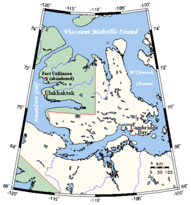
| Map of the island | |
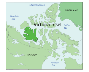
The Victoria Island ( English Victoria Island , Inuktitut Kiilliniq ) is the second largest island in Canada and the eighth largest island in the world (according to other counts the ninth or tenth largest). It is located in the Arctic Ocean in the Canadian Arctic Archipelago and has a size of 217,291 km². The western part of the island belongs politically to the Inuvik region of the Northwest Territories , the eastern part, and thus about two thirds of the area, to the Kitikmeot region of the Nunavut territory .
geography
Victoria Island is around 750 km long in an east-west direction, up to 625 km wide in a north-south direction and in the Shaler Mountains reaches a height of up to 665 m above sea level. To the west of it, only separated by the narrow Prince of Wales Strait , lies Banks Island , to the north is Melville Island and to the east, separated by the McClintock Channel , is Prince of Wales Island . Another larger neighboring island in the southeast is King William Island . Victoria Island is separated from the north American mainland to the south by a strait consisting of Amundsen Gulf , Dolphin and Union Strait , Coronation Gulf , Dease Strait , Queen Maud Gulf and Victoria Strait .
The two settlements on the island are Cambridge Bay (1,477 inhabitants) in the south, the location of a Canadian weather station , and Ulukhaktok (formerly Holman, 398 inhabitants) on the west coast at the entrance to Prince Albert Sound .
history
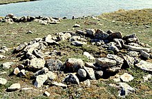
At the Pembroke Site (according to the Borden system NgNc-2), an archaeological site in the southeast of the island, north of Cambridge Bay , the remains of the oldest known Thule- Inuit settlement (see Inuit culture ) were found. This included eleven extensive residential areas, which were evidenced by five tent rings, five light house-like structures sunk into the ground and one qalgiq , a large community structure . Another site was destroyed by road construction in the 1970s; the function of another structure is unclear. The main food sources of the residents were caribou , arctic char and arctic char . In addition, there were very small numbers of marine mammals and birds. The settlement existed around 1400, and thus only 200 years after the first east migration of the Thule people from Alaska to the eastern Arctic region as far as Greenland . It represents the second wave of migration to the east, but to less favorable areas. The Thule people, maybe four to five families, were heading east and may have only been on the island for a few years - the communal building high on the hill suggests an ostentatious occupation, especially since there were dance and music events there should. However, the Pembroke site was only inhabited for a short time. On the other hand, it is possible that the late Dorset people lived in the south of the island and that this required detours from the Thule people; therefore it is unclear whether they went north or south around the large island, although the south route offered better resources. Excavations took place first in 1963 and 1965, whereby first one settlement site, then four others were excavated, but only with 26 artefacts . Starting in 2008, the digging started again, whereby, in addition to the dating and excavation of other residential structures, it was possible to prove that most of the fish was caught in a freshwater stream only 20 m away. The local Kitikmeot Heritage Society , led by Brendan Griebel, managed to involve the population in the excavation project. The qalgiq was reconstructed in the May Hakongak Community Library and Cultural Center and is now used for assemblies.
The island had long been inhabited by Inuit when it was sighted during John Franklin's second expedition in 1826 . It was named after the British Queen Victoria in 1839 and explored in the late 1830s by British researchers Thomas Simpson (1808–1840) and Peter Warren Dease (1788–1863) and in 1851 by John Rae . Richard Collinson wintered twice under cover of the island from 1851 to 1853. Large parts of the coastline were only cleared up by the expeditions of Roald Amundsen 1903-1906 and Vilhjálmur Stefánssons 1915-1917.
In 1923 the Hudson's Bay Company set up its trading posts at Cambridge Bay and Port Brabant (sometimes called Fort Collinson, moved to Holman in 1939, now Ulukhaktok ). In 1926 the Royal Canadian Mounted Police followed with a station in Cambridge Bay.
On the first crossing of the Northwest Passage from west to east, Henry Larsen wintered with the St. Roch in 1940-1941 in Walker Bay in the west of the island.
literature
- Lesley Howse: Late Dorset Caribou Hunters: Zooarchaeology of the Bell Site, Victoria Island , in: Arctic Anthropology 45 (2008) 22-40. ( academia.edu )
Web links
Victoria Island ( English, French ) In: The Canadian Encyclopedia . Retrieved August 22, 2016.
Individual evidence
- ↑ Darren Keith: Inuit Qaujimaningit Nanurnut Inuit Knowledge of Polar Bears (PDF; 7.0 MB). Gjoa Haven Hunters 'and Trappers' Organization and CCI Press, 2005, Appendix 5.
- ↑ The Atlas of Canada - Sea Islands ( Memento from January 22, 2013 in the Internet Archive ) (English)
- ↑ site of Pitquhirnikkut Ilihautiniq / Kitikmeot Heritage Society .
- ^ T. Max Friesen, Lauren EY Norman: The Pembroke Site: Thule Inuit Migrants on Southern Victoria Island , in: Arctic 69 (2016) 1-18 ( academia.edu ).
- ^ William James Mills: Exploring Polar Frontiers. A Historical Encyclopedia , Vol. 1, ABC-CLIO, Santa Barbara / Denver / Oxford 2003, p. 676.
- ↑ Across the Northwest Passage: The Larsen Expeditions on the University of Calgary's Arctic Expedition , accessed May 18, 2013.


