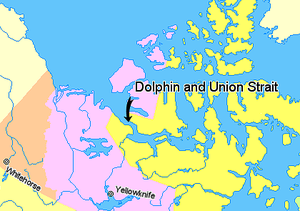
Dolphin and Union Strait
| Dolphin and Union Strait | ||
|---|---|---|
| Location of the Dolphin and Union Strait | ||
| Connects waters | Coronation Gulf | |
| with water | Amundsen Gulf | |
| Separates land mass | Victoria Island | |
| of land mass | Mainland Canada | |
| Data | ||
| Geographical location | 69 ° 51 ′ N , 117 ° 27 ′ W | |
|
|
||
| length | 210 km | |
| Smallest width | 26 km | |
| Islands | Liston Island , Sutton Island , Lambert Island , Camping Island | |
The Dolphin and Union Strait is located between mainland Canada and Victoria Island , which is part of the Canadian Arctic archipelago . It connects the Amundsen Gulf in the northwest with the Coronation Gulf in the southeast. Austin Bay marks the southeast end of the strait .
The Inuit who live in this area are known as the Copper Eskimos , Copper Inuit or the "people of the end of the world".
There are several islands in the strait. These include Liston Island and Sutton Island , which historically represent the home of the Noahonirmiut tribe of the Copper Inuit.
The strait has a length of about 210 km. Their width varies between 26 and 65 km.
In spring, when the strait is still frozen, Barrenground caribou , known as "Dolphin and Union" herds, cross them to get to Victoria Island and spend the summer on it. Eider ducks can be seen in the strait .
In the last few decades, the winter ice thickness in the strait has continuously decreased.

