Jonessund
| Jonessund / Jones Sound | ||
|---|---|---|
| Connects bodies of water | Baffin Bay | |
| with water | Norwegian Bay | |
| Separates land mass | Ellesmere Island | |
| of land mass | Devon Island | |
| Data | ||
| Geographical location | 76 ° 0 ′ N , 86 ° 0 ′ W | |
|
|
||
| length | 200 km | |
| Smallest width | 40 km | |
| Coastal towns | Grise Fiord | |
| Islands | Coburg Island , Smith Island , North Kent Island , Calf Island , Landslip Island | |
| Satellite image | ||
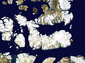
The Jonessund ( English Jones Sound , French Détroit de Jones ) is a strait in the Canadian Arctic . It connects Baffin Bay with Norwegian Bay and runs between Devon Island in the south and Ellesmere Island in the north. It is over 200 km long and between 40 and 80 km wide.
geography
The entire length of the Jones Sound follows the 76th northern latitude . Its outlets are narrowed by large islands, Coburg Island to the east and North Kent Island to the northwest. Access from Baffin Bay is possible through Glacier Strait north of Coburg Island or through Lady Ann Strait south of it. Both straits are about 30 km wide. The entrances in the northwest are much narrower. The Hell Gate ( German "Hell Gate" ) is only 4.4 km wide between Twin Rivers Point (North Kent Island) and Cape Donninghausen (Ellesmere Island), the Cardigan Strait between North Kent Island and Devon Island about 8 km. The coasts of Jonessund are mostly steep because both Ellesmere Island and Devon Island are formed by the mountains of the Arctic Cordillera . Fjords reach deep into the partly glaciated interior of the two islands. The most important are Starnes Fiord , Grise Fiord , Harbor Fiord, Southcape Fiord, Baad Fiord, Muskox Fiord, Goose Fiord and Walrus Fiord in the north and West Fiord and Viks Fiord in the west.
Wildlife
The Jonessund is visited by walruses , white whales and narwhals during the summer . Ringed seals , harp seals , bearded seals and polar bears can be found here all year round . The polynias at both ends of Jonessund provide enough food for large numbers of seabirds to breed here.
At the exit of Jonessund into Baffin Bay is the Nirjutiqavvik National Wildlife Area . Six areas are designated as Important Bird Areas (IBA) . So Skruis Point (NU054) is the largest breeding area of black guillemots in the Arctic. On the rocks of Cape Vera (NU053) nest almost 10,000 pairs of Eissturmvogels , also 300 pairs of Common Eider and glaucous gulls , Thayermöwen and terns . Other IBAs are Cambridge Point (NU010) on Coburg Island, Sydkap Icefield (NU055) on Ellesmere Island, North Kent Island (NU052) and Eastern Devon Island (NU057).
history
On the coasts of Jonessund you can find numerous remains of prehistoric settlement from the Dorset and pre-Dorset times , especially tent rings. When the first Europeans reached it, there were no Inuit settlements here.
Looking for a north-western sea route to China and India , Robert Bylot and William Baffin discovered the entrance to Jonessund on July 10, 1616, which they named after Alderman Jones, one of their clients. Baffin, like John Ross 200 years later, thought Jonessund was a bay.
The first to enter the Jonessund with his ship was Thomas Lee. The captain of the whaler Prince of Wales claimed to have advanced 150 miles into the sound in 1848. In search of the Franklin expedition , William Penny and Horatio Austin found the entrance to the sound blocked by the ice in 1850 and 1851. Edward Inglefield had more favorable ice conditions in 1852. He drove from Baffin Bay into Jonessund and explored the north coast from Devon Island to Cape Sparbo (84 ° 10 ′ west longitude).
The second Norwegian polar expedition with the Fram , which explored the Canadian islands west of Ellesmere Island from 1898 to 1902 under the direction of Otto Sverdrup , wintered three times in Jonessund, first in Harbor Fiord in 1899/1900 and then twice in Goose Fiord. The west coast of Ellesmere Island was captured and the Sverdrup Islands were discovered during extensive dog sledding trips . The expedition members Gunnar Isachsen and Edvard Bay mapped the parts of the Jonessund that were previously unknown.
After his sleigh ride on which he wanted to have reached the North Pole , Frederick Cook wintered at Cape Sparbo in 1908/09.
In 1922, the Royal Canadian Mounted Police established the Craig Harbor outpost on the south coast of Ellesmere Island. In 1956 he was relocated to Grise Fiord , where an Inuit settlement had already been established in 1953. To this day, Grise Fiord is the only permanently inhabited settlement on Jonessund.
literature
- William James Mills: Exploring Polar Frontiers - A Historical Encyclopedia , Vol. 1, ABC-CLIO, 2003, ISBN 1-57607-422-6 (English)
Individual evidence
- ↑ Skruis Point on Bird Studies Canada, accessed April 19, 2018
- ↑ Cape Vera on Bird Studies Canada, accessed April 19, 2018
- ↑ Donald T. Hanna: Architectural Variability in Paleoeskimo Tent Rings From Jones Sound . Dissertation, Simon Fraser University, Calgary 1981 (English)
- ↑ Thomas Rundall: Narratives of voyages towards the north-west, in search of a passage to cathay and india, 1496 to 1631 . The Hakluyt Society, 1848, p. 142 (English)
- ↑ William James Mills: Exploring Polar Frontiers - A Historical Encyclopedia , p. 334 (English)


