Norwegian Bay
Coordinates: 77 ° 30 ′ N , 90 ° 50 ′ W
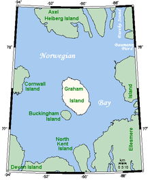
The Norwegian Bay ( German "Norwegian Bay" ) is a bay in the Arctic Ocean in the north of the Canadian territory of Nunavut .
geography
The almost round body of water with dimensions of 161 × 145 km is almost completely surrounded by islands of the Queen Elizabeth Islands . Clockwise (starting in the north) these are Axel Heiberg Island , Ellesmere Island , North Kent Island , Devon Island and Cornwall Island . In the center of the bay are two larger islands, Graham Island and Buckingham Island . To the south is North Kent Island. There is a connection with Baffin Bay via the Jonessund . Only in the northwest is the Massey Sound a wider opening to the ocean.

