Graham Island (Nunavut)
| Graham Island | ||
|---|---|---|
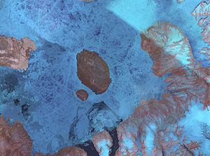
| Graham Island satellite image | ||
| Waters | Norwegian Bay | |
| Archipelago | Queen Elizabeth Islands | |
| Geographical location | 77 ° 26 ′ N , 90 ° 30 ′ W | |
|
|
||
| length | 50 km | |
| width | 35 km | |
| surface | 1378 | |
| Highest elevation | 174 m | |
| Residents | uninhabited | |
Graham Island is an island in Nunavut Territory , Canada , and belongs to the Queen Elizabeth Islands archipelago . It is located in Norwegian Bay between Axel Heiberg Island in the north, Ellesmere Island in the east, Devon Island in the south and Cornwall Island in the west. Buckingham Island is in front of it to the southwest, separated by a strait only four kilometers wide. Graham Island has a size of 1378 km² and is about 50 km long and around 35 km wide. The 90th west longitude cuts the island.
Individual evidence
- ↑ The Atlas of Canada - Queen Elizabeth Islands ( Memento from January 22, 2013 in the Internet Archive ) (English)


