Arctic Cordillera
| Arctic Cordillera | |
|---|---|
|
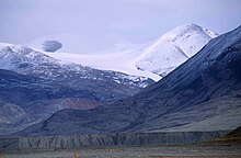
Location of the Arctic Cordillera |
|
|
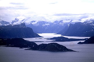
Mountains in Auyuittuq National Park on Baffin Island |
|
| Highest peak | Barbeau Peak ( 2616 m ) |
| location | Canada , North America |
| Coordinates | 82 ° N , 75 ° W |
The Arctic Cordillera ( English Arctic Cordillera ) is a strongly indented mountain range along the northeast coast of North America and at the same time the northernmost mountain range on earth. It is around 1000 km long and extends in Canada from Ellesmere Island via Baffin Island to the northern tip of the Labrador Peninsula . The Arctic Cordillera covers a large part of the Canadian Arctic Archipelago , many of the mountains are glaciated and protrude from ice fields or ice caps . In the east, the Arctic Cordillera is bounded by Baffin Bay , the Davis Strait and the Labrador Sea , and in the north by the Arctic Ocean .
The mountain range is predominantly in the Nunavut Territory , a small part to the southeast in the provinces of Newfoundland and Labrador and Québec . It is divided into several smaller mountain ranges, the mountains of which reach heights of over 2000 m. The highest mountain is the 2,616 m high Barbeau Peak in the British Empire Range on Ellesmere Island, which is also the highest point in eastern North America. The term Arctic Rockies is sometimes used for the Arctic Cordillera , due to its similarity to the better-known Rocky Mountains (part of the Cordillera ) in western Canada. The Arctic Cordillera is also one of Canada's 15 ecoregions .
geography
Most of the Arctic Cordillera lies on Ellesmere Island , Baffin Island , Bylot Island , Devon Island and Bathurst Island , a small part on the northern tip of the Labrador Peninsula .
Protected areas
More than a fifth of Ellesmere Island, the Quttinirpaaq National Park , is under protection. The national park includes seven fjords and a variety of glaciers . There is also Lake Hazen , the world's largest lake north of the Arctic Circle . Barbeau Peak , Nunavut's highest mountain ( 2616 m ) is located on Ellesmere Island in the British Empire Range . The Challenger Mountains , the northernmost mountain range in the world, are located in the northwest region of the island. The northern tip of the island is called Grant Land .
The Sirmilik National Park in the north of Baffin Iceland is known for its large populations of thick-billed murres , kittiwakes and snow geese . The Sirmilik National Park is geographically divided into Bylot Island , the northeast of the Borden Peninsula and an area south of Pond Inlet between Oliver Sund and Paquet Bay .
The Auyuittuq National Park lies on the Cumberland Peninsula in the southeast part of Baffin Iceland. In Inuktitut , the Inuit language , Auyuittuq means "the land that never melts". Auyuittuq was created as a nature reserve in 1976 and was granted national park status in 2000. Well-known mountains are Mount Asgard and Mount Thor with the highest vertical wall in the world.
The Torngat Mountains National Park on the Labrador Peninsula covers a large part of the Torngat Mountains at the southern end of the Arctic Cordillera. It was created in 2005 and is the first national park in the sub-province of Labrador .
Highest mountains


| mountain | Height in m | Remarks |
|---|---|---|
| Barbeau Peak | 2,616 | Highest point in eastern North America |
| Mount Whisler | 2,500 | Second highest point in eastern North America |
| Commonwealth Mountain | 2,225 | |
| Mount Oxford | 2.210 | |
| Outlook Peak | 2.210 | Highest point on Axel Heiberg Island |
| Mount Odin | 2.147 | Highest point on Baffin Island |
| Mount Asgard | 2.015 | |
| Qiajivik Mountain | 1.963 | Highest point in the northern part of Baffin Island |
| Angilaaq Mountain | 1,951 | Highest point on Bylot Island |
| Kisimngiuqtuq Peak | 1,905 | |
| Arrowhead Mountain | 1,860 | |
| Mount Eugene | 1,850 | |
| Ukpik Peak | 1,809 | |
| Mount Nukap | 1,780 | |
| Bastille Peak | 1,733 | |
| Mount Thule | 1,711 | |
| Angna Mountain | 1,710 | |
| Mount Thor | 1,675 | Highest vertical wall in the world |
| Mount Caubvick | 1,642 | Highest point on mainland Canada east of Alberta |
Mountain ranges
Several sub-chains of the Arctic Cordillera have official names. They are:

- Adam Range on the Île Vanier
- Baffin Mountains to the east of Baffin Island
- Blackwelder Mountains to the east of Ellesmere Island
- Blue Mountains to the east of Ellesmere Island
- Boulder Hills in north Ellesmere Island
- British Empire Range to the north of Ellesmere Island
- Bruce Mountains Along to the east of Baffin Island
- Byam Martin Mountains on Bylot Island
- Challenger Mountains to the northeast of Ellesmere Island
- Conger Range in southern Quttinirpaaq National Park on Ellesmere Island
- Cunningham Mountains in south Devon Island
- Douro Range in northwest Devon Island
- Everett Mountains west of Frobisher Bay on Baffin Island
- Garfield Range on north Ellesmere Island
- Geodetic Hills in the center of Axel Heiberg Island
- Grinnell Range in northwest Devon Island
- Grogan Morgan Range in north Bathurst Island
- Haddington Range in northwest Devon Island
- Hartz Mountains in the north of Baffin Island
- Inglefield Mountains in southeast Ellesmere Island
- Innuitian Mountains on Ellesmere Island, Axel Heiberg Island, Bathurst Island, Ile Vanier and northeast Devon Island
- Jeffries Range in north Bathurst Island
- Joy Range in the southeast of Axel Heiberg Island
- Krag Mountains in northern Baffin Island
- Warrior Mountains to the south of Ellesmere Island
- Osborn Range in the north of Ellesmere Island
- Precipitous Mountains in northern Baffin Island
- Prince of Wales Mountains in central Ellesmere Island
- Princess Margaret Range in the center of Axel Heiberg Island
- Sawtooth Range between the Posheim Peninsula and Wolf Valley on Ellesmere Island
- Selamiut Range on the northern tip of Labrador
- Scoresby Hills on east Bathurst Island
- Stokes Range in north Bathurst Island
- Swiss Range in the center of Axel Heiberg Island
- Thorndike Peaks in the south of Ellesmere Island
- Torngat Mountains on the northern tip of Labrador
- Treuter Mountains in north Devon Island
- United States Range to the north of Ellesmere Island
- Victoria and Albert Mountains to the east of Ellesmere Island
- White Triplets Peaks in the center of Axel Heiberg Island
geology
The northern part of the Arctic Cordillera was unfolded during the Inuitian orogeny , when the North American Plate shifted north in the middle of the Mesozoic Era . It consists of igneous and metamorphic rocks, but mostly sedimentary rocks . The mountains on Axel Heiberg Island mostly consist of long ridges of folded Paleozoic and Middle Mesozoic sedimentary rocks with smaller magmatic intrusions .
The Arctic Cordillera is younger than the Appalachians , so erosion has far less deformed the mountains into rounded hills. The mountains are bare as trees can neither survive the extremely cold winter climate nor grow during the summer. Large areas are permanently covered by ice and snow. The Arctic Cordillera is similar to the Appalachian Mountains in composition and has similar minerals . The mineral resources have hardly been explored as exploitation is too expensive due to the remoteness of the region and cheaper alternatives exist further south.
The mountains in the southeastern part of Ellesmere Island consist mainly of gneiss , with minor insets of volcanic rocks. They are considered to be highly eroded, with deep vertical grooves and narrow ridges.
The Arctic Cordillera forms the eastern edge of the Canadian Shield , which covers most of Canada. Precambrian rock is the main component of the basement .
Flora and fauna
The vegetation is very sparse in the harsh climatic conditions, as frost can occur throughout the year and soil is rare. Three quarters of the area are pure rock , even lichens are rare and trees only occur in specially protected places. Plants growing in the region are mostly small species that grow in the form of thick insulating mats to protect themselves from the cold, or are covered with thick hairs for insulation and protection from winds. The plant species that grow here include black spruce , arctic willow , cotton grass , sour grass , moss , grove , rushes , saxifrage , diapensia , arctic poppy , silver arum , alpine sardine , catchwort , blueberry and heather plants .
The conditions are too hostile for reptiles and amphibians to survive here , and insects are also rare. The musk ox and caribou are the only large herbivores, polar bears and arctic wolves the only large carnivores. Smaller herbivores include the arctic hare and collar lemming , while the smaller carnivores include the arctic fox and ermine . Mammals living in the sea include narwhal , white whale , walrus , bearded seal and ringed seal .
Among the people living in the Arctic Cordillera birds include ptarmigan , gyrfalcon , snowy owl , thick-billed murre , kittiwake , Ruddy Turnstone , Red Knot , Black Guillemot , ringed plover , Fulmar , red-throated diver , snow goose and eider .
Climate and settlement
The climate of the Arctic Cordillera is one of the most inhospitable in Canada. In winter the temperature drops to −35 ° C. Tree stumps found on Axel Heiberg Island, around 40 million years old, indicate that this northern part of the Cordillera was once warmer and wetter than it is today.
Just under 1500 people live in the region, mainly in the settlements of Clyde River and Qikiqtarjuaq on Baffin Island. The vast majority are Inuit who make their livelihood from hunting, fishing and trapping.
literature
- Chernoff, MN, HR Hovdebo, and J. Stuart-Smith. Eastern Canadian Cordillera and Arctic Islands An Aerial Reconnaissance . Ottawa: 24th International Geological Congress, 1972.
- Geological Survey of Canada. Cordillera and Pacific Margin Interior Plains and Arctic Canada . Geological Survey of Canada Current Research, 1998-A. 1998.
- Hall, John K. Arctic Ocean Geophysical Studies The Alpha Cordillera and Mendeleyev Ridge . Palisades, NY: Lamont-Doherty Geological Observatory, Columbia University, 1970.
- Walker, Edward R. A Synoptic Climatology for Parts of the Western Cordillera . Montreal: McGill University, 1961.
See also
Individual evidence
- ↑ Barbeau Peak - bivouac.com
- ↑ ParkWardens: Arctic Cordillera Ecozone Overview ( Memento of the original from February 17, 2008 in the Internet Archive ) Info: The archive link was inserted automatically and has not yet been checked. Please check the original and archive link according to the instructions and then remove this notice.


