Kimmirut
| Kimmirut | ||
|---|---|---|
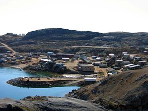
 View of Kimmirut |
||
| Location in Nunavut | ||
|
|
||
| State : |
|
|
| Territory : | Nunavut | |
| Region: | Qikiqtaaluk | |
| Coordinates : | 62 ° 51 ′ N , 69 ° 52 ′ W | |
| Residents : | 450 (as of:) | |
The settlement of Kimmirut ( Inuktitut word for "heel", after a nearby rock formation), Nunavut Territory , before January 1, 1996 Lake Harbor , is located on the south coast of Baffin Island , more precisely: on the Meta Incognita peninsula , on the Hudson Strait , 130 kilometers southwest of Iqaluit and 360 kilometers east of Cape Dorset . It has a population of around 450 (92% Inuit ) and there are many family ties to the residents of the neighboring settlement of Cape Dorset.
Contact with the outside world began in the 17th century when the Hudson's Bay Company first started trading with the Inuit. More intensive contacts arose when whalers from Scotland and the USA stationed whaling ships here from 1860 and a mica mine was opened a little later. In 1900 the Anglican Church established its second mission station on Baffin Island in a bay across from the present-day settlement . In 1911 the Hudson's Bay Company established a trading post, and in 1927 a Canadian Police Post was established . By 1945, Kimmirut, then still called Lake Harbor, became the administrative center for the South Baffin region; with the establishment of the US military base in Frobisher Bay , later the capital of Iqaluit , Kimmirut lost this function and with it its importance.
Many talented people live in Kimmirut . As a result, the production of artistic stone sculptures has become an important source of added value and income for the population.
Kimmirut is known for its tidal range of around 11 meters, which in winter piles up ice walls of up to 10 meters due to the freezing sea water.
The place is the starting point for tours into the Katannilik Territorial Park , which stretches across the Meta Incognita peninsula to Frobisher Bay and is largely dominated by the Soper River .
literature
- Miriam Dewar (Ed.): The Nunavut Handbook: Traveling in Canada's Arctic . Ayaya Marketing & Communications, Iqaluit / Ottawa 2004, ISBN 0-9736754-0-3 (English).
