
Kilmaurs Castle
| Kilmaurs Castle | ||
|---|---|---|
 Discarded field stones at the presumed location of Kilmaurs Castle |
||
| Creation time : | unknown | |
| Castle type : | Niederungsburg | |
| Conservation status: | Burgstall | |
| Standing position : | Scottish nobility | |
| Place: | Kilmaurs | |
| Geographical location | 55 ° 38 '7.7 " N , 4 ° 30' 40.6" W | |
| Height: | 93 m ASLTemplate: height / unknown reference | |
|
||

Kilmaurs Castle is an abandoned low castle on the site of Jocksthorn Farm near Kilmaurs in the Scottish administrative division of East Ayrshire . Timothy Pont wrote about them in the early 17th century:
“The fort is an old, strong building that belongs to the Earl of Glencairn, surrounded by a beautiful park called Carmel Wood, past which Carmel Water flows.” “(...) The baron's old mansion is said to be about half a mile southeast of Kilmaurs, where you can still see some ruins on the Jock's-thorn farm, probably the original Villam de Cuninghame - the family's first estate. "
The castle should not be confused with the later possession of the ' Cunninghame family called Kilmaurs Place , whom Dobie called in 1876 "compared to this modern".
history
In 1527, Cuthbert Cunninghame is said to have lived in both Jocksthorn and Kilmaurs Place, “on the assumption that Jocksthorn is actually Kilmaurs Castle and that instead of the now ruinous building escape from the end of the 16th or beginning of the 17th century at The Place previous building. After the construction of the later The Place, the castle must soon have been abandoned and fell into disrepair.
The map by Timothy Pont from around 1600 shows a typical tower castle in an enclosure with a second area of fenced, light forest that runs along Carmel Water . It shows a mill and a house from "Karmel-Wood"; a farm with this name has been preserved to this day. The property is known as "Kilmaers" and is located south of the church. Only one tower is recorded in the area and Jocksthorn is not mentioned. Kilmaurs Castle is the only property in the area shown with a second, wooded enclosure.
In 1612, John Monipennie stated that Kilmaurs Castle was the residence of the Earls of Glencairn , which suggests that Kilmaurs Place was not built then, at least not in the form of a suitable residence.
Moll s map from the early 1700s shows a castle but no fences. Jocksthorn and Kilmore Place are not listed.
The Statistical Account of 1791-99 says of the Earl of Glencairn: “This noble family resided in this parish at the time, where they had a house, some of which were small ruins on a farm called the Jock's-thorn and near the Road from Stewarton to Kimlmarnock is still preserved (...) ”.
Roy's military map of the area from the 1750s shows a large area of possible sparse forest that has not yet been cultivated where Kilmaur's Castle is believed to have stood. Armstrong's map from 1775 shows a castle-style building at the presumed location, although the name "Jock's Thorn" seems to be associated with it.
Adamson stated in 1875 that the old castle was in the neighborhood of Jock's or Jack's Thorn Farm , now Jocksthorn , and many old Kilmaurs could remember in 1875 playing among the ruinous remains of brickwork that made up the location of this old castle the Cunninghames covered.

Adamson also speaks of the typical, open wooded area of such a dwelling, which still existed in the 1870s with venerable old trees, which sounds like roundels of trees, avenues that lined streets and bridle paths, etc. All of this is usually not associated with farms and he seems to reinforce the argument that this is the location of a castle by describing a "(...) turf-covered, round mound " or a moth at the "traditional" location.
In the years 1884–1886 the Gazetteer of Scotland records that “(...) a neighboring farm, Jock's Thorn, contains traces of the original or older residence of the Glencairn family to whom Kilmaurs has bestowed the title of baron, both because they were the Earls of Glencairn and also 53 years earlier ”.
Cartographic evidence of a crenellated building at this point has been recorded by the Royal Commission on the Ancient and Historical Monuments of Scotland (RCAHMS), presumably a typical Scottish tower castle.
The lack of building blocks at this location and the clear records of ruins at this very spot indicate a high level of “theft” in favor of construction projects such as Jocksthorn Farm , Kilmaurs Place and other buildings. The old castle stood on a road that made it possible to easily transport building materials to other construction sites.
More evidence on site
The word part "Thorn" from Jocksthorn could denote a tower, as in Jocks-Thorn in Great Cumbrae . "Aka Jock-Torn; a head, an elevation, so a tower hill ”. “Thorn” occurs in words that mean gathering, gathering place, and property or clearing.
At the traditional location, there is a large number of sorted field stones along the hedge that leads to the Jockthorn Farm .
Even if the location is not particularly easy to defend, it offers an extraordinary panoramic view of the area, as can be seen in the picture gallery below:
- Views from the location of Kilmaurs Castle
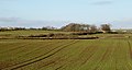
Bellsland Farm and looking northeast
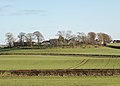
Grassmillside Farm and looking southeast
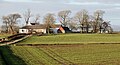
Jocksthorn Farm and view to the northwest

St Maurs-Glencairn Church, tour and view to the south west


Canmore says that “slight undulations suggest previous disturbances, and many large, misshapen stones have been thrown against an adjacent hedge. The farmer from Jocksthorn reports that this is difficult, stony terrain to plow (...) ”.
Davis reports that the local farmer noticed that plowing plowed earthenware and stones on an elevated spot outside the old entrance to Jocksthorn Farm at a point east of the Tour House and Jock's Thorn.
With metal detectors, a number of medieval coins were found in this area between possible building blocks of old buildings and foundations. The 6-inch Ordnance Survey Map of Kilmaurs shows the presumed location of Kilmaurs Castle off the access road to Jocksthorn Farm , which branches off the road to Stewarton.

Dobie states in 1874 that the baron's residence was about a mile southeast of Kilmaurs and that ruins could still be seen on the Jocksthorn land.
| etymology |
| According to McNaught, “Carmel”, whose oldest form is “Caremuall”, is derived from the Scottish Gaelic “Car” (German: Fort) and “Meall” (German: Hill). Hence: "Fort on a hill". |
Local history
Dobie reports that the castle was in a park called "Carmel Wood," named after Carmel Water . A farm called "Carmellwood" is northeast of the castle location.
The Tour Burn flows underground in a drainage channel from Stewarton Road at Grassmillside to near the corner of an adjacent field near Tour's lands. It is not known whether this is in any way related to the agricultural needs of the castle, its mound, the associated lands, gardens, etc.
The site is 2 miles from Kilmarnock and 5 miles from Stewarton.
Individual evidence
- ↑ James D. Dobie, JS Dobie (editor): Cunninghame, Topographized by Timothy Pont 1604-1608, with continuations and illustrative notices . John Tweed, Glasgow 1876. p. 283.
- ↑ a b c d James D. Dobie, JS Dobie (editor): Cunninghame, Topographized by Timothy Pont 1604–1608, with continuations and illustrative notices . John Tweed, Glasgow 1876. p. 289.
- ^ A b c Michael Davis: The Castles and Mansions of Ayrshire . Self-published 1991. p. 301.
- ^ Timothy Pont, Joan Blaeu: Cuninghamia / ex schedis Timotheo Pomt; Ioannis Blaeu excudebat. Cunningham . National Library of Scotland. 1654. Retrieved October 13, 2017.
- ^ Herman Moll: The Shire of Renfrew with Cuningham [i. e. Cunningham . The North Part of Ayr [i. e. Ayr] by H. Moll] . National Library of Scotland. 1745. Retrieved October 13, 2017.
- ^ Sir John Sinclair (editor): The Statistical Account of Scotland . Volume III: '' Ayrshire ''. 1791-1799. P. 328.
- ^ Roy's Map of Ayrshire .
- ^ Andrew Armstrong: A new map of Ayrshire . National Library of Scotland. 1775. Retrieved October 13, 2017.
- ^ A b c Archibald R. Adamson: Rambles Round Kilmarnock . T. Stevenson, Kilmarnock 1875. p. 168.
- ↑ 1884–85 Ordnance Gazetteer of Scotland, Volume 4 . National Library of Scotland. P. 378. Retrieved October 13, 2017.
- ↑ a b Entry on Kilmaurs Castle in Canmore, the database of Historic Environment Scotland (English)
- ^ Cumbrae Local Names . Retrieved January 5, 2015.
- ^ Ordnance Survey Language Resources . Retrieved October 13, 2017.
- ^ Duncan McNaught: Kilmaurs Parish and Burgh . A. Gardner, 1912.
- ↑ Ayr XVII.5 (Kilmaurs). Survey date: date 1856. Publication: 1860 . National Library of Scotland. 1860. Retrieved October 13, 2017.