King Island (Alaska)
| King Island | ||
|---|---|---|
| Waters | Bering Sea | |
| Geographical location | 64 ° 58 ′ 0 ″ N , 168 ° 5 ′ 0 ″ W | |
|
|
||
| length | 2.5 km | |
| width | 2.2 km | |
| surface | 3.91 km² | |
| Highest elevation | 200 m | |
| Residents | uninhabited | |
| main place | Ukivok (historical) | |
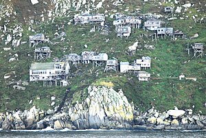
| The abandoned Inupiat village of Ukivok was built on stilts | ||
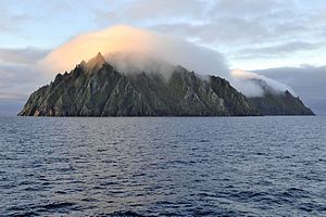
King Island ( Inupiaq : Ugiuvak ) is an island in the Bering Sea west of the Seward Peninsula of Alaska . The island is located about 40 miles west of Cape Douglas . It consists primarily of a 200 m high and 2.5 km long rock.
She was discovered in 1778 by James Cook , who named her on board after his lieutenant, Lt. James King (1750–1784), named.
Originally, King Island was the winter home of around 200 Inupiat who called themselves Aseuluk . The Aseuluk, whose name is Ukiwuk for King Island , spent their winters on the island hunting. In the summer she was drawn to the mainland in what is now Nome , Alaska. There they sold the booty they had hunted in winter (especially the furs).
At the beginning of the 1950s, more and more of the Aseuluk moved to Nome all year round (in 1960 only 50 Aseuluk lived on the island in winter), before the entire island remained uninhabited from 1970. The 45 houses, the Catholic church and the school building in the only village have been falling into disrepair since then.
The fauna of the island includes the crested falcon , a medium-sized species from the alken family .
Web links
- King Island (Alaska) in the Geographic Names Information System of the United States Geological Survey
Single receipts
- ^ Anthony J. Gaston and Ian L. Jones: The Auks . Oxford University Press, Oxford 1998, ISBN 0-19-854032-9 , p. 245


