Kings Mountain National Military Park
| Kings Mountain National Military Park | ||
|---|---|---|
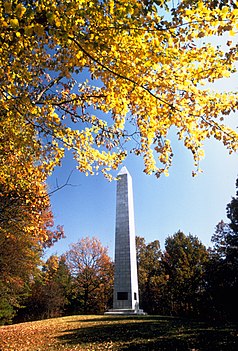
| Kings Mountain Monument | ||
|
|
||
| Location: | South Carolina , United States | |
| Next city: | Bethany | |
| Surface: | 15.96 km² | |
| Founding: | March 3, 1931 | |
| Visitors: | 268,394 (2005) | |
| Address: | www.nps.gov/kimo | |
Kings Mountain National Military Park is a national military park not far from the city of Blacksburg in the state of the United States South Carolina in the southeastern United States . The park is on the border with neighboring North Carolina . It commemorates the battle of Kings Mountain , a decisive and important victory of the patriots over the loyalists loyal to the king during the American Revolutionary War .
The battle took place on October 7, 1780. The American patriots smashed the left wing of the army of British commander Charles Cornwallis and ended the so far successful campaign of the loyalists in the Carolinas . The victory ended the British advance into North Carolina and forced Cornwallis to withdraw from Charlotte to South Carolina. This gave Nathanael Greene the opportunity to reorganize the forces of the United States Army . Many of the soldiers who lost their lives at Kings Mountain had previously fought in other battles. The youngest fighters were 10 years old, the oldest 50, the youngest to die was 15 year old Billy Rowland.
To commemorate the events of the battle, the establishment of Kings Mountain National Park was decided on March 3, 1931 by the United States Congress . The park also marks the end of the Overmountain Victory National Historic Trail , which is reminiscent of the route of the Overmountain Men who rushed from the Appalachians to take part in the battle on the side of the patriots.
Visitors to the park can use a two-and-a-half kilometer long path that follows the patriots' line-up from the visitor center and leads to the hill on which the British took their positions. The path gives an overview of the battlefield and leads past Patrick Ferguson's grave as well as a number of smaller and larger monuments, the first of these monuments dates from 1815. Since the path is very steep in some places, it becomes in the Part of the National Park Service's centenary initiative to make it easier for visitors to use.
The park is followed by Kings Mountain State Park , which has campsites and picnic areas for visitors and shows on a living history farm how people used to live and work there. The state park is located approximately 50 kilometers south of Charlotte and approximately 100 kilometers north of the city of Greenville , South Carolina. The mountain that gives the area its name, Kings Mountain can be seen from Interstate 85 North for several kilometers.
Individual evidence
- ↑ http://www.nps.gov/2016/assets/files/Summary-of-Park-Centennial-Strategies.pdf Mary A. Bomar: Summary of Park Centennial Strategies ( PDF , English). National Park Service, August 2007. Retrieved February 15, 2008.

