Kitselas Canyon
| Kitselas Canyon National Historic Site of Canada Lieu historique national du Canada du Canyon-Kitselas |
|
|---|---|
|
Historic Place of Canada Lieu patrimonial du Canada |
|
| Recognized since | October 19, 1972 |
| Type | National Historic Site of Canada |
| ID | 10522 |
| place | Regional District of Kitimat-Stikine , British Columbia |
| Coordinates | 54 ° 36 ′ 20 ″ N , 128 ° 26 ′ 0 ″ W |
| Recognized by | Canadian Federal Government |
| Approved by | Historic Sites and Monuments Act |
| Entry Canadian List of Monuments | |
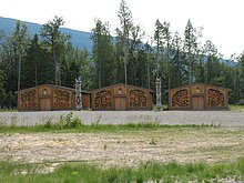
Kitselas Canyon , often called Gitselas Canyon , is a stretch of the Skeena River northeast of Terrace in British Columbia . It was declared a National Historic Site of Canada on October 19, 1975 by the Canadian government .
The Tsimshian have lived in the coastal region for over 10,000 years, and have lived in Kitselas Canyon for at least 5000 years. The Gitselasu (also known as Kitselas , the people of the gorge), one of the seven First Nations of the Tsimshian in northwestern British Columbia, lived here and established settlements that controlled access to the Pacific through the river's valley.
Five villages are known in the canyon. The oldest sites are Tsunyow, Gitaus and the Paul Mason Site . The latter site was named after Paul Mason, one of the elders of the tribe who took part in the archaeological dig in 1981 . The village is dated between 1200 and 600 BC. The oldest finds are 5000 years old. These early artifacts are tiny blades that came from an obsidian site 350 km southeast, the area around Anahim on the Chilcotin Plateau. The Paul Mason Site was probably a seasonal warehouse until a village was built there. The site gave its name to a phase of cultural development, the Paul Mason phase (approx. 1200 to 700 BC), in which permanently inhabited houses were built. The residents dried salmon. However, while the other villages in the Canyon show clear signs of a hierarchically structured society, such as houses of very different sizes, everything about the Paul Mason Site points to an egalitarian society. All three sites were abandoned centuries ago, the Paul Mason Site so long ago that it left no trace in the memory of the tribe.
The villages of Gitlaxdzawk and Gitsaex are the youngest, with the former originally located on an island. However, this became a peninsula due to a landslide during the construction of the Grand Trunk Pacific Railway between 1910 and 1913. The village with over 300 inhabitants was fortified and served to ward off invaders who came up the river. It consisted of ten longhouses, the largest of which was Sim'oogit Gaum from the Ganhada clan (raven clan). The great smallpox epidemic of 1862 forced the residents to give up the village.
Diagonally opposite was the village of Gitsaex, which consisted of 17 long houses. This village with around 600 inhabitants also had to be abandoned in 1862.
Although no people lived on the neighboring islands of Dry Island and Ringbolt Island, there were four and five petroglyphs, respectively .
In this section, the Skeena River is divided into three narrow watercourses, narrowed by rocky banks, which were the greatest obstacle to steam navigation at the beginning of the 20th century between Port Edward and Hazelton . The ships did not go through the rapids, but were pulled through the bottleneck with the help of cables. Some boats - like the Mount Royal , which carried a not inconsiderable load of gold - sank. Today a trail leads to Ringbolt Island (about an hour), where you can still see metal rings anchored in the rock, which were used to tow the ships.
In 2016, 306 of the 691 recognized Gitselas lived mainly in two of the ten reserves , one is Kulspai or Queensway reserve (New Town), diagonally across from Terrace. On a rock above the canyon, in the Gitaus reserve (Git'aws means people of the sand ), a second settlement has emerged, which is increasingly becoming the cultural center of the tribe.
Until its dissolution in 2005, the overarching Tsimshian Tribal Council represented the Gitselasu in contract negotiations with the governments of Ottawa and Victoria . The Gitselasu are gradually expanding the Gitselas Canyon into an important site for tourism.
literature
- Gary C. Coupland: Prehistoric Cultural Change at Kitselas Canyon , unpublished. Dissertation, Vancouver: University of British Columbia Press 1985
Remarks
- ↑ Kitselas Canyon National Historic Site of Canada. In: Canadian Register of Historic Places. Retrieved October 17, 2013 .
- ^ Village of Paul Mason Site ( Memento November 11, 2009 in the Internet Archive )
- ↑ Registered Population - Kitselas. Indigenous and Northern Affairs Canada, April 9, 2019, accessed September 11, 2019 .

