
Small Gosau glacier
| Small Gosau glacier | ||
|---|---|---|
 View of the Great Gosau Glacier (left) and Small Gosau Glacier (center) 2010 |
||
| location | Upper Austria | |
| Mountains | Dachstein Mountains | |
| Type | Mountain Glacier Karst Glacier | |
| length | 0.53 km | |
| surface | 0.902 km² (DORIS 2019) | |
| Exposure | northwest | |
| Altitude range | 2660 m above sea level A. - 2380 m above sea level A. | |
| Coordinates | 47 ° 28 '48 " N , 13 ° 35' 3" E | |
|
||
| particularities | Shadows and snow supply from avalanches | |

The Kleine Gosaugletscher is a small glacier in the western Dachstein massif .
Location and description
Like the northern and southern Torstein glaciers, the Kleine Gosaugletscher lies in the inner corners of the high north-west exposed cirque of the Torstein ( 2947 m ), in whose shadowy corner a large part of the nutrient area is located. In addition, at the Kleiner Gosaugletscher, the south-west slope of the Hohe Schneebergwand contributes as a further protective factor to the fact that this glacier is the largest of the Torstein glacier with around 9 hectares . The mean height is around 2500 m, it measures from the glacier approach at around 2660 m to the glacier edge at around 2380 m but only around 0.5 km.
Historical glacier stands
A coherent glaciation of the Great Gosau Glacier with the Torstein Glacier (Kleiner Gosau Glacier, Northern and Southern Torstein Glacier) can be assumed for the Egesen high stand . As a result of the rise in temperature around 10,000 years ago and the leveling off of glacier sizes to (early) recent values, the Great Gosau Glacier separated from the Torstein Glacier.
The high level of 1850 and the retreat phases of the Kleiner Gosau Glacier
The Kleine Gosaugletscher and the Northern Torstein Glacier also formed a coherent ice mass during the peak period of 1850, as late as 1885 Fr. Simony used the term "Torstein Glacier". R. Moser set the separation of the two glaciers in the years 1884 to 1896. By the time the AV map was published in 1915, the independent names Kleiner Gosaugletscher, Nördlicher and Südlicher Torsteingletscher had already been established.
Picture gallery
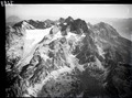
Aerial view of the Dachsteinstock with the glaciers of the Gosau roof in 1933 (ETH Library)
literature
- Rainer Hochhold: The glaciers of the Dachstein group . Geographic Institute of the Univ. Innsbruck. 1978; Digitized: The glaciers of the Dachstein group
- Roman Moser: The glaciation in the Dachstein and its traces in advance . Geographic Institute of the Univ. Innsbruck. 1954
- Roman Moser: Dachstein Glacier and its traces in advance . Hallstatt Museum Association (ed.). Hallstatt. 1997; 143 pp.
- Friedrich Simony: About the fluctuations in the spatial extent of the glaciers of the Dachstein Mountains during the period 1840–1884 . Mitt. D. Geogr. Ges. Wien Vol. 28: 1885; Pp. 113-135
- Friedrich Simony: The Dachstein area. A geographical character image from the Austrian Northern Alps . Vienna (E. Hölzl); 1895: 152 pp.
Individual evidence
- ↑ Values measured using the ruler function in May 2019 from: Digital cadastral map of the Austrian land survey in Upper Austria or Google Earth image taken in 2015; Information and access May 2019
- ^ Rainer Hochhold: The glaciers of the Dachstein group . Ed .: Institute of Geography at the University of Innsbruck. 1978, p. 64 ( The glaciers of the Dachstein group [PDF; accessed on May 11, 2019]).
- ^ Friedrich Simony, 1895, p. 139
- ^ Roman Moser, 1954, pp. 84/85
- ↑ Dachstein Group Alpine Club Card. Photo by L. Aegerter, 1: 25,000; Edited by D. u. Ö. Alpine Club. Cartography Establishment G. Freytag & Berndt AG; Vienna, 1915