
Great Gosau glacier
| Great Gosau glacier | ||
|---|---|---|
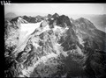
 View to the Great Gosau Glacier (left) with Hohem Dachstein ( 2995 m ), Mitterspitz and Torstein 2010 |
||
| location | Upper Austria | |
| Mountains | Dachstein Mountains | |
| Type | Mountain Glacier Karst Glacier | |
| length | 1.78 km (DORIS 2019) | |
| surface | 1.369 km² (1998) | |
| Exposure | northwest | |
| Altitude range | 2710 m above sea level A. - 2300 m above sea level A. | |
| Coordinates | 47 ° 28 '43 " N , 13 ° 36' 0" E | |
|
||
| drainage | no superficial drainage (cave system) | |
| particularities | Shadows and snow supply from avalanches | |

The Great Gosau Glacier is one of the three larger glaciers in the Dachstein massif .
Location and description
The Great Gosau Glacier is one of the three larger Dachstein glaciers, along with the Hallstatt Glacier and the Schladming Glacier.It is formed by the Schreiberwandgrat in the north, the Hohes Kreuz ridge ( 2837 m ) - Niederer Dachstein ( 2934 m ) in the south, and the Hohe Dachstein ( 2995 m ) in the south m ) and Mitterspitz ( 2922 m ) and surrounded in the west by the Hohe Schneebergwand. The average height is around 2500 m , it measures the glacier approach below the Upper Wind Luke ( 2746 m ) at 2,710 m to the edge of the glacier at about 2,300 m 1.78 km, the area was in 1969 still 153.5 ha, 1998 136.9 ha and now covers less than 100 ha.
The Great Gosaugletscher thus has a very low position of the snow line ( equilibrium line = border between nutrient and consumption area). This is also due to a not inconsiderable part of the high rock framing and the resulting increased shade and increased snow supply from avalanches . As a typical karst glacier, the Schneeloch glacier has no surface drainage; the meltwater is drained through an underground cave system.
In the run-up to the Great Gosau Glacier, the Adamekhütte ( 2196 m ) was built by the Austria Section of the PES on the so-called “Brotstein” in 1906/1907 .
Historical glacier stands
For the Egesenstand a contiguous Gosau glacier from the nutrient areas of the Great Gosau Glacier and the Torstein Glacier ( Kleiner Gosau Glacier , Northern and Southern Torstein Glacier ) can be assumed. In 1885 Friedrich Simony still speaks of a connected "Torstein Glacier". The southern Torstein glacier , recognizable by a narrow moraine corridor , was probably already isolated from the northern Torstein glacier at that time ; the separation of the northern Torstein glacier from the small Gosau glacier is said to have taken place in the years 1884 to 1896.
Moraine complexes directly at or near the Adamekhütte up to ramparts parallel below the marked path to the Hohen Riedel are interpreted differently in the literature and require further investigation , especially with regard to the Egesen and Taubenriedel ranges of the Hallstatt Glacier .
The high level of 1850 and the retreat phases of the Great Gosau Glacier
According to reports from Friedrich Simony, the Great Gosau Glacier reached its highest level in 1848/49, the lowest point of the maximum level was at 1920 m . From 1849 to 1884 the glacier retreated horizontally by approx. 620 m, the firn sections had also decreased noticeably since 1850, the firn cover next to the lower and upper wind hatches had already been partially interrupted. The moraine walls of the 1850 stand are very well preserved and almost model-like near the Adamekhütte and in the tongue area as a dead straight ridge up to 10 m high.
Around 1915, the glacier separated into two lobes of tongue ; the comparatively strong re-melting of the left tongue in the period from 1928–1952 was particularly striking. In the 1970s, the Great Gosau Glacier was at an altitude of around 2810 m to 2250 m , the length was 2.2 km, the snow line ( GWL ) was around 2475 m .
It is interesting that in the mid-1970s on the Great Gosau Glacier z. T. not insignificant advances were measured. From 1982, however, the continuous decline, which also brought about the complete melting of the left tongue, continued, a tendency that has essentially continued unabated to the present. Since the middle of the 19th century, significantly more than 50% of the glacier area has been lost, and the tongue has retreated by around 1500 m since then.
Picture gallery

View to the Great Gosau Glacier with Hohem Dachstein ( 2995 m ), Mitterspitz and Hoher Schneebergwand.
Aerial view of the Dachsteinstock with the glaciers of the Gosau roof in 1933 (ETH Library)

High Dachstein and Great Gosau Glacier
Dachstein massif and Great Gosau glacier in the early morning

The Great Gosau Glacier in August 2006 (photo montage)

View of the Adamekhütte and the Great Gosau Glacier with the moraine of the elevated position from 1850 and older moraines in the foreground
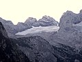
View into the tongue area of the raised stand from 1850 on the Gr. Gosau glacier, above and on the top right deposits of the former Torstein glacier

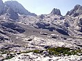
Moraine around 1850 and current glacier size in the background
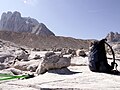
View of the "model moraine" of the high stand from 1850 and the Hohe Schneebergwand, in the foreground a beautifully designed karst table with a base height of around 10 cm

Coarse-block moraine near the AV path to the Adamekhütte in the extended apron of the Great Gosau Glacier


Web links
source
- Rainer Hochhold: The glaciers of the Dachstein group . Ed .: Institute of Geography at the University of Innsbruck. 1978 ( The glaciers of the Dachstein group [PDF; accessed on May 11, 2019]).
literature
- Roman Moser: The glaciation in the Dachstein and its traces in advance . Geographic Institute of the Univ. Innsbruck. 1954
- Roman Moser: Dachstein Glacier and its traces in advance . Hallstatt Museum Association (ed.). Hallstatt. 1997; 143 pp.
- Hans Kinzl: Contributions to the history of the glacier fluctuations in the Eastern Alps . Z. f. Gletscherkunde Vol. 17, H. 1-3: 1929; Pp. 66-121
- Hans Kinzl: The karst tables - a means of measuring the lime removal . In: Communications of the Austrian. Geogr. Gesellschaft Vol. 117, pp. 290-303; 1975
- Friedrich Simony: About the fluctuations in the spatial extent of the glaciers of the Dachstein Mountains during the period 1840–1884 . Mitt. D. Geogr. Ges. Wien Vol. 28: 1885; Pp. 113-135
- Friedrich Simony: The Dachstein area. A geographical character image from the Austrian Northern Alps . Vienna (E. Hölzl); 1895: 152 pp.
Individual evidence
- ↑ Values measured using the ruler function in May 2019 from: Digital cadastral map of the Austrian land survey in Upper Austria or Google Earth image taken in 2015; Information and access May 2019
- ↑ http://tirolatlas.uibk.ac.at . R. Moser (1997; p. 33) gives the area for 1991 only as 127.5 ha
- ↑ Value determined by the area measurement function in May 2019 from: Digital cadastral map of the Austrian land surveying in Upper Austria ; May 2019
- ^ Rainer Hochhold: The glaciers of the Dachstein group . Ed .: Institute of Geography at the University of Innsbruck. 1978, p. 24 ( The glaciers of the Dachstein group [PDF; accessed on May 11, 2019]).
- ↑ The story of the Adamek hut
- ^ Friedrich Simony, 1895, p. 139
- ^ Roman Moser, 1954, pp. 84/85
- ^ Rainer Hochhold: The glaciers of the Dachstein group . Ed .: Institute of Geography at the University of Innsbruck. 1978, p. 64 ( The glaciers of the Dachstein group [PDF; accessed on May 11, 2019]).
- ^ Friedrich Simony, 1885, p. 131
- ^ Roman Moser, 1954, p. 73
- ↑ Hans Kinzl, 1929, p. 102
- ^ Roman Moser, 1954, p. 76f
- ^ Rainer Hochhold: The glaciers of the Dachstein group . Ed .: Institute of Geography at the University of Innsbruck. 1978, p. 86 ff. or 95 ( The glaciers of the Dachstein group [PDF; accessed on May 11, 2019]).