
Schladming Glacier
| Schladming Glacier | ||
|---|---|---|
 The Schladming Glacier from the Hohen Gjaidstein (July 2006) |
||
| location | Upper Austria | |
| Mountains | Dachstein Mountains | |
| Type | Mountain glacier | |
| length | 0.75 km (2018) | |
| surface | 0.68 km² (2015) | |
| Exposure | Northeast | |
| Altitude range | 2670 m above sea level A. - 2540 m above sea level A. | |
| Ice thickness | ⌀ 9 m; Max. 30 m (1987) | |
| Ice volume | 8 × 10 6 m 3 (1987) | |
| Coordinates | 47 ° 28 '12 " N , 13 ° 37' 49" E | |
|
||

The Schladming Glacier is the third largest glacier in the Dachstein Mountains in Austria after the Hallstatt Glacier and the Great Gosau Glacier .
Historical glacier stands and research
A contiguous plateau glaciation on the Dachstein can be assumed for the Gschnitz stage after the disintegration of the ice flow network in the late glacial period , the separation of the Schladming Glacier from the Hallstatt Glacier should finally take place after the Daun stage and also apply to the Egesenstand . Since there are no concrete indications of late glacial stages in the area apart from isolated ground moraine remains, reconstructions of older glacier positions on the Schladming Glacier are only possible mathematically with the help of snow limit estimates.
With regard to postglacial glacier positions, a 50 m long piece of rampart in the run-up to the 1850 moraine, which connects to the northeast-running rock spur of the Koppenkar, is described in the literature. Roman Moser assigned this moraine to the "early" Fernau advance in the 16th century. However, the coarse blockiness and the degree of leaching indicate a possibly older age. A parallelization of these deposits with the moraines of the Taubenriedelstand on the Hallstatt Glacier and the equally large-block moraines in the run-up to the Great Gosau and Schneeloch glaciers would be obvious, but is not mandatory.
The high level of 1850 and the retreat phases of the Schladming Glacier
Friedrich Simony described the Schladming Glacier in the middle of the 19th century as generally poor in crevices, the glacier only showed an incline of about 45 degrees when it fell towards the Großer Koppenkarstein and there were also deep crevasses. The growth period was completed between 1840 and 1850, since then there has been a constant decrease in mass and area. Even at the maximum level, the glacier had no pronounced tongue like the Hallstatt Glacier or the Great Gosau Glacier, it ended in a broad front, the discharge took place several hundred meters above ground through a stream, which eventually dried up in the numerous sinkholes and karst tubs.
The high level of 1850 can still be traced in the area through well-preserved moraine walls. The moraine arch extends from the northeast spur of the Koppenkarstein (2320 m) to the southern foothills of the Mitterstein (2350 m). The wall is interrupted at its deepest point at 2250 m up to 150 m, which is due to meltwater. At the time of the high level around 1850, the Schladming Glacier was still connected to the extensive flank glaciation of the eastern slopes of the Hohe Gjaidstein, which continued to exist for a long time. Characteristic for the further melting of the Schladming Glacier was the frequent "drowning" of the glacier tongues in the rubble. The glacier also repeatedly changed shape as it melted back and split into numerous lobes and tongues.
In 1850 the Schladming Glacier had an area of 2.163 km², in 2015 it was only approximately 0.680 km². The glacier has thus lost more than ⅔ of its area since 1850. The lowest point is currently (2018) around 2540 m (valley station of the Schladminger lift), the glacier hardly shows any flow movement, the connection to the Hallstätter glacier in the area of the Gjaidstein saddle apert is becoming more and more difficult .
Picture gallery

The apron of the Schladming Glacier with the moraine walls of the high altitude from 1850

Moraine landscape of the high level from 1850

Coarse-block moraine near the 1850 high moraine

Karst table in the extended apron of the Schladming Glacier


Nature conservation, cable car construction and mass tourism
In 1963 the central Dachstein area was declared a nature reserve, in 1998 it was included in the "UNESCO World Cultural Heritage" "Hallstatt, Salzkammergut, Dachstein". The Dachstein-Südwandbahn from the Türlwandhütte (1692 m) to the Hunerkogel (2687 m), which opened in 1969, marked the beginning of a phase of mass development and use of the glacier areas through paths, glacier lifts, cross-country trails and “alpine” attractions such as a suspension bridge into nowhere , the Skywalk or an ice palace covered with tarpaulin in summer. Due to the dimensions and the large number of technical systems, however, the consequences of tourist overuse such as dramatic pollution of the glacier surface and all kinds of garbage (plastic, cans, batteries, ...) in a highly sensitive alpine region that is actually under nature protection cannot be overlooked.

Schladming Glacier with groomed cross-country trails

Summer skiing on the Schladming Glacier!?
Lift supports on the Gjaidstein saddle

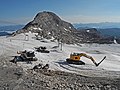
Gjaidstein saddle with covered ice palace and infrastructure

Glacier lift valley station


Alpine farming and legends
The alpine pastures on the plateau are referred to by Vischer as Zlacken (Lackenmoosalm), im Lang Kohr (Langkaralm), Das Gaid (Gjaidalm), Taubenkor (Taubenkaralm), Schenbihel (Schönbichlalm) and Matteregg (Modereckalm). The names Schladminger Alm and Verfallene Alm can also be found. Southeast of the Schladming Glacier at 2040 m above sea level. A. is the Brunngrube or Lange Grube. In 1996 a late Bronze Age settlement was discovered in this elongated cirque. A 14 C-dating yielded an age of 3,385 years. Similar finds are also known from other mountain regions and glacier foreland.
The legend of the doused Alm reflects the past heyday of the Dachstein Mountains . A long time ago, so the legend goes, there was enough fodder in the lush alpine meadows for the cows, which gave plenty of milk, so that large wheels of cheese and spicy butter strangles filled people's storage boxes. However, this abundance made people proud and cocky, and they began to wash and bathe in the milk. As if that weren't enough, they covered the floors with wheels of cheese and clogged the joints with butter. As a punishment for this outrage, it began to snow and snow and snow in large flakes, and the snowfall did not cease for weeks, so that the mountain pastures were buried under the snow, which soon froze to ice.
This legendary motif of the doused mountain pasture, which is often found in the Alpine region in connection with glaciers, is perhaps reminiscent of the Little Ice Age , a dramatic deterioration in the climate that began around 1580 and lasted for over 100 years. At that time, many alpine pastures could only be used to a limited extent, and individual pastures even had to be abandoned. However, this legend is possibly even older and is based on the existence of Bronze Age settlements, which are now reappearing in the course of the glacier retreat caused by global warming . The stone wreaths on the foundations of long-derelict alpine huts testify to a bygone bloom.
literature
- Rainer Hochhold: The glaciers of the Dachstein group . Geographic Institute of the Univ. Innsbruck. 1878. Digitized: the glaciers of the Dachstein group
- Hans Kinzl: Contributions to the history of the glacier fluctuations in the Eastern Alps . In: Z. f. Glacier Science. Volume 17, H. 1-3: 1929, pp. 66-121.
- Franz Mandl, Harald Stadler (Hrsg.): Archeology in the Alps. Everyday life and cult (= research reports from ANISA 3 / Nearchos Volume 19). House in the Ennstal 2010.
- Franz Mandl: Schladminger and Hallstätter Glaciers, Dachstein Mountains. Glacier report 2018 . ANISA FB 3, 2016; ANISA research reports for the Internet. 3, 2016 .
- Franz Mandl: The loss of mass and the subsidence of the ice of the Schladming Glacier between 1850 and 2014 . ANISA FB 1, 18, 2014. ANISA research reports for the Internet. 1, 2016 .
- Roman Moser, Alfred Mayr: Areas and mass losses of the Dachstein glacier. In: Yearbook of the Upper Austrian Museum Association. Volume 104, Linz 1959, online (PDF) in the forum OoeGeschichte.at.
- Roman Moser: The glaciation in the Dachstein and its traces in advance. Geographic Institute of the Univ. Innsbruck, 1954.
- Roman Moser: Dachstein Glacier and its traces in advance. Museum Association Hallstatt (Ed.): Hallstatt. 1997, 143 pp.
- Friedrich Simony: About the fluctuations in the spatial extent of the glaciers of the Dachstein Mountains during the period 1840–1884. In: Mitt. D. Geogr. Ges. Vienna. Volume 28, 1885, pp. 113-135
- Friedrich Simony: The Dachstein area. A geographical character image from the Austrian Northern Alps. E. Hölzl, Vienna 1895, 152 pages.
Web links
Individual evidence
- ^ Orthophoto [1] DORIS-Intermap of the Province of Upper Austria
- ↑ Mandl, F., 2018: [2] DORIS-Intermap des Landes Oberösterreich
- ^ University of Vienna, Central Institute for Meteorology and Geodynamics: Seismic ice thickness measurements of Austrian glaciers. In: Archive for deposit research of the Federal Geological Institute. Vienna 1987, Volume 8, pp. 27/28; on-line; PDF file; 320 kB
- ^ University of Vienna, Central Institute for Meteorology and Geodynamics: Seismic ice thickness measurements of Austrian glaciers. In: Archive for deposit research of the Federal Geological Institute. Vienna 1987, Volume 8, pp. 27/28; on-line; PDF file; 320 kB
- ↑ See Hochhold, R. Chap. 4 (p. 18 f) and 66f. As a reference level for the snow line ( equilibrium line ) at the time of the high altitude around the middle of the 19th century, a value of 2525 m can be well represented, e.g. Z. the Egesenstand this was around 200 m lower
- ^ Moser, R., 1954: p. 60
- ↑ Hochhold, R., p. 58f
- ↑ Simony, Fr., 1895: pp. 138 and 159
- ^ Moser, R., 1954: p. 78
- ↑ See Alpine Club Map 1915
- ^ Moser, R., 1954: p. 81
- ↑ Moser, R./Mayr, A., 1959: S. 179/180. The calculations by Franz Mandl (ANISA research reports for the Internet FB 1, 18, 2014 and ANISA FB 3, 2016) result in an area of 2.598 km² without the glacier portion along the Hohen Gjaidstein ( 2794 m above sea level ), with the partial glaciated Mittersteinkar even up to 3.814 km² Source: Orthofoto, DORIS-Intermap of the Province of Upper Austria
- ↑ Mandl, F., 2018; Orthophoto, DORIS-Intermap of the Province of Upper Austria, the slopes were not taken into account
- ↑ derdachstein.at