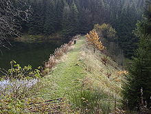
Little Clausthal
The Kleine Clausthal , also known as Klein Clausthal or Klein-Clausthal , is a valley on the southwestern outskirts of Clausthal-Zellerfeld in the Clausthal district in the Upper Harz in Lower Saxony .
description
The Little Clausthal begins at its highest point ( 595 m above sea level ) directly on the outskirts of Clausthal (Mühlenstraße; Marie-Hedwig-Straße crossing) and extends over a total of approx. 1600 m initially in a westerly direction and after approx. 800 m in a west-southwest direction and flows out finally to about 480 m above sea level. NHN in the innermost valley. Its width is between 150 m and 400 m.
In the upper area of the valley there are meadows on both slopes that are used as pastures. The lower part of the valley is forested by spruce trees . In the forest area there are also numerous heather areas in clearings .
A natural stream runs through the bottom of the valley and is dammed a few hundred meters before it flows into the Upper Innerste to form the “Klein Clausthaler Teich”, an artificial pond belonging to the Upper Harz water shelf .
Furthermore, the valley is cut in a south-north direction by the watercourses "Oberer Klein Clausthaler Wasserlauf" and "Unterer Klein Clausthaler Wasserlauf", which are also created for mining purposes, which arise from the watercourses "Oberer Johannisthaler Wasserlauf" and "Unterer Johannisthaler Wasserlauf" respectively. The watercourses can be recognized by their day openings ( mouth holes ) in the area.
literature
- M. Schmidt: The Upper Harz mining oak . Stuttgart: Verlag Konrad Wittwer, 1987.
- J. Teicke: UNESCO World Heritage Upper Harz Water Management - The Upper Harz Water Shelf . Clausthal-Zellerfeld: The Upper Harz Mining Museum, 2011.
- Maps (ADAC city map Clausthal-Zellerfeld and hiking map West Harz from LGN)
Web links
Coordinates: 51 ° 47 ′ 59.7 " N , 10 ° 18 ′ 51.4" E

