
Via ferrata in Bad Bleiberg

The "BGV" via ferrata and the "Extreme" via ferrata are two via ferratas of easy to difficult difficulty levels ( A – E ) in the municipality of Bad Bleiberg , Villach-Land district , Carinthia , Austria .
Location and course
Coming from Nötsch im Gailtal or Villach via Bleiberger Straße (Landesstraße L35) to Bad Bleiberg (902 m). Near the spa center Bad Bleiberg (920 m) take the driveway with the signs "Hotel am Kolm". Parking is available at the hotel. Then follow the signposted forest road on foot. About 100 meters after the second bend, there is a sharp entry on the right-hand side, indicated by a red sign, onto a trampling path that leads to the entrances on the Traninger Wand (1100 m).
The two via ferratas are connected to each other and separated by signs. This makes it possible to get from the BGV via ferrata to the extreme via ferrata and vice versa. From the via ferrata you have an excellent view of, among other things, Bad Bleiberg with the spa center and the Dobratsch . There are also some accessible old mining tunnels along the via ferrata. With grades A to E, the via ferratas combine all levels of difficulty of via ferrata.
BGV via ferrata
The Bergmännische Gesangsverein (BGV) -Klettersteig is named after the people who maintained the climb and leads as a circular route through the left part of the Traninger Wand. After easy climbing at the entrance, follow the secured path to two secured ladders that lead into the upper section of the forest. From there, follow the secured trail to the left and return to the entrance via a serpentine -like descent over a rocky slope. With the exception of a small C point at the first, slightly overhanging metal ladder, the rest of the BGV via ferrata is rated as easy levels of difficulty A and B.
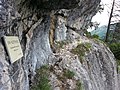
Start of the BGV via ferrata

The two ladders

Tunnel entrance on the BGV via ferrata


Extreme via ferrata
Coming over the BGV via ferrata, follow the steel cable past the two metal ladders and get to the extreme via ferrata. This leads over an extremely low-step, inclined, partly overhanging rock wall crossing of the Traninger Wand at a height of around 35 meters (difficulty D and E ). After the traverse, there is a steep ascent into the forest area, which leads to the sometimes very steep descent over a rocky slope. The narrow path at the foot of the wall at the end of the descent leads back to the entrance.

Entry from the BGV-Steig

View from the entrance to the steep crossing

View from the ascent area into the steep crossing


Web links
Coordinates: 46 ° 37 ′ 54.1 " N , 13 ° 40 ′ 12.3" E