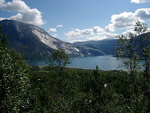
Kobbvatnet
| Kobbvatnet / Gåpjávrre | ||
|---|---|---|

|
||
| Between Narvik & Mo i Rana Norway | ||
| Geographical location | Sørfold , Nordland , Norway | |
| Drain | Kobbelva → Leirfjord | |
| Data | ||
| Coordinates | 67 ° 37 '19 " N , 15 ° 58' 9" E | |
|
|
||
| Altitude above sea level | 8 m | |
| surface | 5.07 km² | |
| length | 4 km | |
| width | 2.5 km | |
| scope | 12.8 km | |
Kobbvatnet (Lulessami Gåpjávrre ) is a lake in the municipality of Sørfold in Nordland in Norway . The 5.07 km³ lake is located about 10 km southeast of the village of Mørsvikbotn , on the E6 .
See also
Individual evidence
- ↑ a b c d NVE. (No longer available online.) Archived from the original on September 21, 2012 ; Retrieved January 25, 2013 . Info: The archive link was inserted automatically and has not yet been checked. Please check the original and archive link according to the instructions and then remove this notice.
- ↑ Gåpjávrre. In: yr.no. Retrieved January 25, 2013 (Norwegian).
