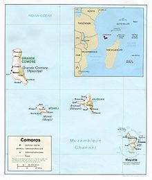
Comoros archipelago
The Comoros archipelago is located northwest of the island of Madagascar , off the African continent. The main islands are Grande Comore , Anjouan , Mohéli and Mayotte . The islands are of volcanic origin and are populated by a total of almost a million people.
Politically, the islands are divided into two units:
- The sovereign state Union of Comoros and
- Mayotte , a French overseas territory .
The islands and other geographical parts of the archipelago in detail:
- Grande Comore or Ngazidja is the largest and youngest of the islands. Here is Moroni , the capital of the Union of Comoros. The Karthala volcano here has been active again for several years and scientists expect an eruption in the near future.
- Anjouan or Nzwani , a large Union island with separatist aspirations
- Mohéli or Mwali , also part of the Union, also have separatist tendencies
- Mayotte , island under French administration
- Pamanzi , the second largest island in Mayotte, is the only airport in the French region of Dzaoudzi
- Banc du Geyser , a reef , mostly below the surface of the water, probably remnants of a sunken island. In the southern part, some rocks rise 1.5-3 meters above the water surface
- Banc du Leven , also a reef below the surface of the water and probably the remains of a sunken island
- Banc Vailheu , northwest of Grand Comore, at low tide up to 7 m below the water surface. Reaches the surface soon and should develop into an island
- occasionally - geographically hardly tenable - the uninhabited Îles Glorieuses are also included in the archipelago. They are located a few hundred kilometers east of the Comoros and are under French administration. Until 1975 they were administered from the Comoros
Flora and fauna
There are a number of endemic (only indigenous) animals and plants on the islands .

