
Kuelporr
Coordinates: 67 ° 48 ′ 6.6 ″ N , 33 ° 36 ′ 8.9 ″ E

Kuelporr ( Russian Куэльпорр ) is a base of the Russian Mountain Rescue (Kontrolno-spassatelnaja Sluzhba, KSS), in which a small hotel and a Banja are. It is located on the Kola Peninsula in the Kunijok Valley, in the center of the Chibinen , in the Russian Oblast of Murmansk . Kuelporr is located on the territory of the Kirovsk district .
Kuelporr is one of the few permanently inhabited places in the mountains. It can be reached from Kirovsk via a road about 25 kilometers long, but in summer it is only accessible with off-road vehicles. The station is named after a 901.8 m high mountain about three kilometers south-southeast .
Kuelporr is a popular destination for campers and also serves as a base for day trips for hikers and mountaineers. About a kilometer away there is an (unspectacular) waterfall , which is also quite popular with tourists; In the immediate vicinity of the waterfall there is a ridge in which experiments with the code names Dnepr-1 and Dnepr-2 on the use of nuclear explosions in mining were carried out in 1972 and 1984 . The relatively small "atomic bombs" ignited in tunnels had an explosive force of 2.1 and 1.7 kilotons respectively . According to employees of the mountain rescue service, radiation that is classified as dangerous for humans can no longer be measured there.
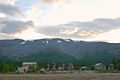
Kuelporr with a small hotel and a mountain rescue station

To the left of the valley is Kuelporr, to the right of it the ridge in which the core blasts were carried out, recognizable by the overburden from the tunnel

Mountain rescue station


Individual evidence
- ↑ Soviet General Staff Map 1: 100,000. Sheet Q-36-7.8
- ↑ Ispytanija jadernogo oružija i jadernyje vzryvy v mirnych celjach SSSR. 1949–1990 against RFJaZ-VNIIEF, Sarow 1996, ISBN 5-85165-062-1 (Russian, nuclear weapons tests and nuclear explosions for peaceful purposes of the USSR. 1949–1990 ). , PDF ( Memento from February 1, 2012 in the Internet Archive )