Cultural port of Duisburg
The cultural port (and the southern port that shares the same entrance to the Rhine) is a port on the right bank of the Rhine in Duisburg at river kilometer 775 and is on the border of the Duisburg districts of Hochfeld and Wanheimerort opposite the Rheinhausen district . The cultural harbor forms the southern border of the Rheinpark Duisburg-Hochfeld. It is located directly up the Rhine next to the Duisburg-Hochfelder railway bridge . To the east of the port there is a port station that belongs to the Duisburg-Hochfeld Süd station .
history
In 1866 the Rheinische Eisenbahn-Gesellschaft built its Ruhr area route south of Hochfeld, starting from the Rheinhausen – Hochfeld trajectory at today's cultural port. For this purpose, the mouth of the Dickelsbach was dredged and fortified. The barges lying there could also be sailed.
Cultural and historical significance
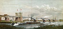
As a former ferry port, the Kultushafen is a contemporary witness of the technology used to cross the Rhine before the bridge was built. Together with the railway bridge in operation, the area of the former freight yard in Hochfeld and the southern port, it forms an ensemble of historical value for the history of the railway crossings over the Rhine. This historical testimonial value is particularly high for Duisburg, as it is the first and oldest railway bridge in the city over the Rhine. The historical connection with the oldest industrial area in the city of Duisburg in Hochfeld can be read through the spatial proximity and the visual relationships.
Future use
As part of the IGA -2027 project, there is the consideration of filling up the harbor basin of the cultural harbor and building a sandy beach in its place. The adjoining southern harbor is then to be turned into a yacht harbor.
Web links
Individual evidence
- ↑ https://www.waz.de/staedte/duisburg/duisburg-plant-marina-und-hafenstrand-am-rhein-id212090589.html
Coordinates: 51 ° 24 '25.9 " N , 6 ° 44' 55.2" E


