Kulu
|
Kulu Кулу |
||
|
|
||
| Data | ||
| Water code | RU : 19010100112119000003444 | |
| location | Khabarovsk Region , Magadan Oblast ( Russia ) | |
| River system | Kolyma | |
| Drain over | Kolyma → Arctic Ocean | |
| confluence | von Chudschach and Kenjelitschi 61 ° 52 ′ 22 " N , 145 ° 33 ′ 26" E |
|
| Union | with Ajan-Jurjach to Kolyma Coordinates: 62 ° 17 ′ 41 ″ N , 147 ° 43 ′ 51 ″ E 62 ° 17 ′ 41 ″ N , 147 ° 43 ′ 51 ″ E
|
|
| length | 300 km (with the source river Kenjelitschi 384 km) | |
| Catchment area | 15,600 km² | |
| Discharge at the Kulu A Eo gauge : 10,300 km² Location: 83 km above the mouth |
MQ 1942/1994 Mq 1942/1994 |
95 m³ / s 9.2 l / (s km²) |
|
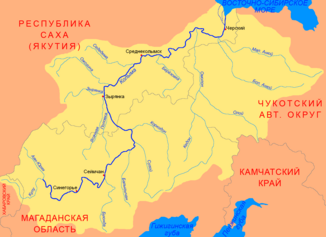
Course of the Kulu (Кулу) in the catchment area of the Kolyma |
||
The Kulu ( Russian Кулу ) is the right source river of the Kolyma in Eastern Siberia .
It arises in the Khabarovsk region at the confluence of the Khujach (left) and Kenyelichi (right) rivers . These arise in the Suntar Chajata Mountains . The Kulu flows first to the south-southeast, reaches the border with Magadan Oblast, and then turns to the northeast and later to the north. After 300 km the Kulu meets the Ajan-Jurjach and unites with it to form Kolyma . Together with the right source river Kenjelitschi, the river length is 384 km. The Kulu drains an area of 15,600 km². The river is ice-covered between October and the end of May.
Individual evidence
- ↑ a b c Article Kulu in the Great Soviet Encyclopedia (BSE) , 3rd edition 1969–1978 (Russian)
- ↑ a b Kulu in the State Water Directory of the Russian Federation (Russian)
- ↑ Kulu at the Kulu gauge - hydrographic data at R-ArcticNET
