
Kume-jima
| Kume-jima | ||
|---|---|---|
 |
||
| Waters | Pacific Ocean | |
| Archipelago | Okinawa Islands | |
| Geographical location | 26 ° 21 ' N , 126 ° 47' E | |
|
||
| length | 12 km | |
| surface | 59.53 km² | |
| Highest elevation | Uegusuku-dake 310.4 m |
|
| Residents | 8243 (January 1, 2015) 138 inhabitants / km² |
|
| main place | Kumejima | |
 |
||

Kume-jima ( Japanese 久 米 島 , Okinawaisch : Kumijima ) is an island of the Okinawa Islands of the Ryūkyū chain of islands .
geography
The 59.53 km² island consists of two groups of hills. The northern group with the Uegusuku-dake ( 宇 江城 岳 ) of 310.4 m height as the highest elevation was formed in the Pliocene and consists of andesite overlaid by tuff-like sandstone , tuff-like siltstone , tuff and coarse sandstone. Separated by a plain, there is a southern group with the Āra-dake ( ア ー ラ 岳 ) of 287.8 m as the highest elevation, which was formed from andesite in the Miocene .
In addition to the north coast, the island is surrounded by coral reefs. In the southwest there is a coral reef about 6 km in length, consisting of the segments Nishime-saki ( 西 銘 崎 ), Iri-bishi, Naka-bishi, Uku-bishi and Mae-bishi. While Nishime-zaki and Iri-bishi constantly rise above the water level, the other segments only appear at low tide.
The island has a subtropical climate with an average annual temperature of 22.4 ° C and an annual rainfall of 2200 mm.
Associated land masses
500 m east is the island of Ou-shima ( 奥 武 島 , also auch-shima, Ou-jima, Ō-jima ), another 250 m is the island Ōha-jima ( オ ー ハ 島 ), also Agariō (-jima) ( 東 奥 武 (島) , "East Oushima") and 300 m northwest of Ōha-shima the island of Ichunza-iwa ( イ チ ュ ン ザ 岩 ).
These three islands lie within a coral reef, which forms a closed hook of more than 10 km in length to the north of the islands up to the easternmost elevation Ugan-zaki ( 御 神 崎 ).
After that, it continues, but repeatedly interrupted, further south to the south of Ou-shima and then southwest to the southern tip of the island with the elevation Shimajiri-saki ( 島 尻 崎 ). The section between Ugan-saki and Ōha-jima forms three large single coral sandbanks - Mēnuhama ( メ ー ヌ 浜 , “front beach”), Naka no Hama ( ナ カ ノ 浜 , “middle beach”) and Hate no Hama ( は て の浜 / ハ テ の 浜 , "beach at the end"), the latter also being used as a collective term for all three - with a total length of 7 to 8 kilometers.
Itachaku-jima ( 一 着 島 ) is located between Iri-bishi and the island .
There are also various reefs, the largest of which has a land area of 0.82 km², as well as six more with areas of at least 0.01 km² (one hectare) - these seven reefs have a total area of 1.49 km².
| Surname | Area [km²] | Coordinates |
|---|---|---|
| Reef 7 | 0.82 | |
| Ou-shima | 0.63 | 26 ° 20 ′ 19 " N , 126 ° 49 ′ 47" E |
| Hate no hama | 0.53 | 26 ° 20 ′ 51 ″ N , 126 ° 53 ′ 13 ″ E |
| Ōha-jima | 0.37 | 26 ° 20 '25 " N , 126 ° 50' 23" E |
| Ugan-zaki | 0.32 | 26 ° 21 '28 " N , 126 ° 55' 49" E |
| Reef 3 | 0.27 | |
| Reef 1 | 0.20 | |
| Naka no Hama | 0.17 | 26 ° 20 '23 " N , 126 ° 51' 43" E |
| Mēnuhama | 0.13 | 26 ° 20 '16 " N , 126 ° 51' 12" E |
| Reef 6 | 0.09 | |
| Reef 5 | 0.06 | |
| Shimajiri-saki | 0.04 | 26 ° 17 ′ 35 " N , 126 ° 48 ′ 55" E |
| Reef 2 | 0.03 | |
| Itachaku-jima | 0.02 | 26 ° 20 ′ 47 " N , 126 ° 43 ′ 42" E |
| Reef 4 | 0.02 | |
| Ichunza-iwa | 0.02 | 26 ° 20 ′ 49 " N , 126 ° 50 ′ 11" E |
|
|
||
In total there are 16 smaller islands with at least one hectare of land around Kume-jima.
administration
Administratively, the islands belong to the municipality of Kumejima , whereby as of January 1, 2015 Kume-jima was inhabited by 8243 people in 3911 households, Ou-shima by 19 people in 14 households. In 1960 there were still 134 people living on the latter island.
tourism
Kume-jima is known for its beaches. Mēnuhama, Naka no Hama and Hate no Hama are 7 to 8 kilometers long sandbanks and thus islands that consist exclusively of beach.
On the east coast of Kume-jima, the sandy beach Eef Beach ( イ ー フ ビ ー チ , Īfu Bīchi ) stretches from the height of Ou-shima to halfway to Shimajira-saki .
Another attraction are the tatami-ishi ( 畳 石 , “ tatami stones”), a 50 × 250 m field of hexagonal stones that look like the pattern of a turtle shell. These are a natural monument of the prefecture.
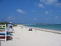
Eef Beach
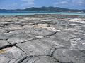
Tatami-ishi

Hate no hama


Flora and fauna
The rivers Uraji-gawa and Shirase-gawa ( 白 瀬 川 ) have their source in the northern group of hills . There are also many small streams and oxygen-rich underground watercourses. This water-rich ecosystem is home to many rare species, such as the 60 cm long adder Opisthotropis kikuzatoi, which lives in the streams, and the firefly Luciola owadai , which was first described in 1993, both of which only occur on Kume-jima, as well as the turtle species Geoemyda japonica, which is only found on the Okinawa -Islands occurs. Therefore, this stream ecosystem is under nature protection and was declared a Ramsar area in October 2008 . Other rare species are the Lidgecko Goniurosaurus kuroiwae yamashinae that poison snake Sinomicrurus japonicus Takarai , the frog Rana okinavana , the violets pigeon Columba janthina , the freshwater crabs Candidiopotamon kumejimense and Geothelphusa Kumejima , the Beetle Allomyrina dichotoma inchachina and Prosopocoilus dissimilis kumezimaensis and the worm Satsuma mercatoria kumejimaensis . The vegetation is characterized by forests of the pseudo-chestnut Castanopsis Sieboldii ssp. lutchuensis and the pine Pinus luchuensis .
history
During the Ryūkyū Kingdom , Kume-jima was often visited by Chinese messengers, known as sapposhi , who were on their way to Shuri in Okinawa. When the Ryūkyū Kingdom was conquered by Japan in 1609, the new rulers banished the old elites to the remote island.
After the island was occupied by the USA in 1945, an area of 2 hectares in the coral reef between Ōha-jima and Ugan-saki has been used as the Kume Jima Range ( 久 米 島 射 爆 撃 場 , Kume-jima shabakugekiba ) shooting range since September 14, 1962 , first by the US Navy , from February 27, 1978 by the US Air Force for ground attacks with aircraft during simulated instrument approaches.
Remarks
- ↑ for reading 島 as shima see siehe 1 指定 離島 ・ 島 し ょ ・ 人口 , p. 1
- ↑ a b c In the source for the areas there are only the entries 砂州 (最 東 1) , 砂州 (最 東 2) and 砂州 (最 東 3) , i.e. H. literally "sand bank (extreme east 1–3)". The area information does not correspond to the dimensions of the official topographic map , which also lists a fourth sandbank further east, but the dimensions on aerial photographs.
Individual evidence
- ↑ a b c d e 指定 離島 ・ 指定 離島 一 覧 . In: 離島 関係 資料 (平 成 28 年 1 月) . 沖 縄 県 企 画 部 地域 ・ 離島 課 ("Land and Islands Unit, Planning Department, Okinawa Prefecture"), January 2016, p. 1 , accessed August 1, 2016 ( Japanese).
- ↑ ク ミ ジ マ . In: 語彙 詳細 - 首 里 ・ 那覇 方言 / Shuri-Naha Dialect Dictionary. Retrieved December 1, 2012 (Japanese).
- ↑ a b c Tatsuo Takahashi, Motoharu Koba: Emerged Holocene Coral Reefs around Kume Island, Ryūkyūs . In: The Science Reports of the Tohoku University , 7th Series (Geography) . Vol. 27, pp. 149-151 ( PDF ). PDF ( Memento of the original from December 1, 2015 in the Internet Archive ) Info: The archive link was inserted automatically and has not yet been checked. Please check the original and archive link according to the instructions and then remove this notice.
- ↑ a b c 町 の 概要 . (No longer available online.) Kumejima Ward, archived from the original on Nov. 1, 2015 ; Retrieved August 1, 2016 (Japanese). Info: The archive link was inserted automatically and has not yet been checked. Please check the original and archive link according to the instructions and then remove this notice.
- ↑ a b Streams in Kume-jima. (PDF; 554 kB) In: Conservation and Wise Use of Rich and Diverse Wetlands: Ramsar Sites in Japan. Environment Ministry , 2008, p. 42 , accessed on December 1, 2012 (English).
- ↑ a b c 久 米 島 / 奥 武 島 / オ ー ハ 島 . (No longer available online.) In: 沖 縄 の し ま じ ま . Okinawa Prefecture, archived from the original on March 21, 2013 ; Retrieved January 3, 2013 (Japanese). Info: The archive link was inserted automatically and has not yet been checked. Please check the original and archive link according to the instructions and then remove this notice.
- ↑ Chiaki Katagiri, Hirohisa Yamada, Tsunehisa Sakihara, Tetsuya Nakajima, Hiroki Miyagi, Yoshirō Watanabe: 久 米 島 の 水中 文化遺産 見 学会 報告 〜 海底 遺跡 ミ ュ ー ジ ア ム – 構想 の 実 践 〜 / Water The Heritage Report in The Project of 'The Museum of Underwater Cultural Heritage'– . In: 沖 縄 県 立 博物館 ・ 美術館 、 博物館 紀要 / Bulletin of the Museum, Okinawa Prefectural Museum & Art Museum . No. 5 , 2012, p. 23 ( PDF ). PDF ( Memento of the original from August 1, 2016 in the Internet Archive ) Info: The archive link was inserted automatically and has not yet been checked. Please check the original and archive link according to the instructions and then remove this notice.
- ↑ a b c イ ー フ ビ ー チ . In: 日本 の 森 滝 渚 100 選 . 日本 の 森 ・ 滝 ・ 渚 全国 協議 会 , accessed January 3, 2013 (Japanese).
- ↑ 2 空軍 . (8) FAC 6080 久 米 島 射 爆 撃 場(Kume Jima Range). In: 沖 縄 の 米 軍 基地 . Okinawa Prefecture, Mar 2003, pp. 314-315 , accessed December 1, 2012 (Japanese).