
Kusatsu-Shirane
| Kusatsu-Shirane | ||
|---|---|---|
 |
||
| height | 2160 m TP | |
| location | Kantō , Gunma Prefecture , Japan | |
| Coordinates | 36 ° 38 ′ 37 ″ N , 138 ° 32 ′ 0 ″ E | |
|
||
| Type | Stratovolcano | |
| Last eruption | 23rd January 2018 | |

The Kusatsu-Shirane ( Jap. 草津白根山 , Kusatsu Shirane-san ), officially only Shirane ( 白根山 , san ), is a 2160 m TP high stratovolcano on the Japanese island of Honshu . The mountain is located 6 km west of the small town of Kusatsu in Gunma Prefecture in the north of the Kantō region , 150 km northeast of Tokyo .
_(Number).jpg)
- Shirane
- Mizugama
- Karegama
- Yugama
- Yumi-ike
- Ai-no-mine
- Futago-yama ( 双子 山 )
- Northern crater of Kagami-ike
- Motoshirane summit
- Kagami-ike
- Western crater of Motoshirane
- Motoshirane's main crater
- Kusatsu Onsen
It is one of the more active volcanoes in Japan, with 14 eruptions recorded since 1805 alone . The last smaller eruption so far occurred on January 23, 2018. From historical times only phreatic explosions around the volcanic crater and current crater lakes Yugama ( 湯 釜 'hot water boiler' ; 36 ° 38 ′ 35 ″ N , 138 ° 32 ′ 9 ″ E ) , Mizugama ( 水釜, kettle ' ; 36 ° 38' 42.5 " N , 138 ° 32 '20" O ), Karegama ( 涸釜, desiccated boiler' ; 36 ° 38 '30 " N , 138 ° 31' 59" O ) and Yumi-ike ( 弓 池'Bogenteich' ; 36 ° 38 ′ 12 ″ N , 138 ° 31 ′ 57 ″ E ). Neither lava nor pyroclastic currents were observed.
Two kilometers south of Shirane main cone is of 2171 m TP ( 36 ° 37 '22.5 " N , 138 ° 31' 54.2" O ) high ash cone Motoshirane ( 本白根山san , German , original Shirane ' ). Its north-western crater is the Kagami-ike crater lake ( 鏡 池'mirror pond' ; 36 ° 37 ′ 25 ″ N , 138 ° 32 ′ 20 ″ E ).
Between Shirane and Motoshirane in turn is the Ai-no-mine ( 逢ノ峰 ; 36 ° 38 '3 " N , 138 ° 32' 8" O ) with 2110.1 m TP
The volcano is located in a special zone of the Jōshin'etsu-Kōgen National Park near several ski areas.

Summit region of the Kusatsu-Shirane
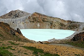
Yugama crater


Web links
- Kusatsu-Shirane in the Global Volcanism Program of the Smithsonian Institution (English)
- Kusatsu-Shirane Volcano. In: Geological Survey of Japan. National Institute of Advanced Industrial Science and Technology (AIST), Japan, accessed January 23, 2018 .
Individual evidence
- ↑ a b Japanese man killed by falling rocks after volcano erupts at ski resort. CNN , January 23, 2018, accessed January 24, 2018 .
- ↑ Kusatsu-Shirane Volcano - Eruptions in historical times. In: Geological Survey of Japan. National Institute of Advanced Industrial Science and Technology (AIST), Japan, accessed on January 23, 2018 (the last eruption on January 23, 2018 was added to the 13 listed eruptions).
- ^ Map of the Jōshin'etsu-Kōgen National Park. (PDF, 2.114 kB) Ministery of the Environment, accessed on January 24, 2018 (English).