Lübsche weather
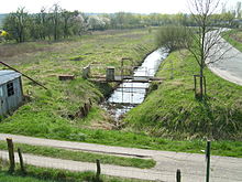
The Lübsche bettors is in Itzehoe left of sturgeon located bettors through which a part of the local Störmarsch is dewatered.
course
The eastern part of the Wetter runs south of the former Alsen site along the Kremper Weg. Before the B 77 , it goes around today's supermarket area and then passes under the “Vor dem Delftor” road piped in a north-easterly direction. On the other side, the Wetter trench then runs along Georg-Löck-Straße to the Stördeich.
The western part of the Lübschen Wetter runs from the route of the Marschbahn north of the Wellenkamper Chaussee through the Störmarsch to the west to the sand dike and then along the border between Itzehoe and Heiligenstedten to the south of the B 5 .
The weather finally drains in a north-easterly direction through the municipality of Heiligenstedten and via a pumping station into the Stör ( location ).
Origin of name
The name comes from the town of Itzehoe, which was granted Lübsche town charter in 1238 . The area "Lübscher Kamp" in today's suburb of Wellenkamp, which has been part of the Itzeho municipal legal area since 1303, was later named after this, the name of which still exists today in the street name "Lübscher Kamp". Not to be confused is the Lübsche Wetter with the Lübscher Kamper Wetter further south-west , which also drains the left-hand Störmarsch.
Expansion close to nature
As already happened in 2006 for the Lübscher Kamper Wetter, the Lübsche Wetter was also to be expanded in parts close to nature in order to improve the biotope function of the water in its bank area and to increase the water retention capacity in the relevant water section through the associated expansion of the water cross-section . After lengthy coordination with the Heiligenstedten Sielverband in previous years, these plans were implemented in summer 2009 and the over one kilometer section of the weather between the sand dike and the railway line was widened.
Individual evidence
- ↑ See agenda item 10 of the minutes of the meeting of the Environment and Allotment Garden Committee of the City Council of Itzehoe on February 24, 2009.
- ↑ See project report 607 - 09/02 from October 20, 2009 in the minutes of the meeting of the main committee of the city council of Itzehoe from November 2, 2009.

