
La Digue
| La Digue | ||
|---|---|---|
.jpg) |
||
| Waters | Indian Ocean | |
| Archipelago | Seychelles | |
| Geographical location | 4 ° 21 '34 " S , 55 ° 50' 13" E | |
|
||
| length | 5 km | |
| width | 3 km | |
| surface | 9.81 km² | |
| Highest elevation |
Nid d'Aigles (Eagle's Nest Mountain) 333 m |
|
| Residents | 2200 (2008) 224 inhabitants / km² |
|
| main place | La Passe | |

La Digue is the smallest of the three main inhabited islands of the Seychelles . Around 2200 inhabitants, who are called Diguois , live on 9.81 square kilometers . The beach section Anse Source d'Argent with its granite formations is considered a dream beach and is a popular tourist destination. La Digue is also the main island of the La Digue and Inner Islands district , one of the 25 administrative districts of the Seychelles, which also includes the more than twice as large Silhouette Island and other islands.
geography
The fourth largest of the granite islands in the Seychelles is located around 50 kilometers northeast of the main island of Mahé and six kilometers east of Praslin . La Digue is about five kilometers long and three kilometers wide, the area is 9.81 km². The island is almost completely surrounded by a coral reef , which is furthest away from the coast in the west and southeast with 380 to 610 meters and in the southwest with 75-100 meters. Overall, the sea area protected by the reef is around 4.5 square kilometers. The highest point on the island is the Nid d'Aigles (in German: Eagle's Nest) at 333 meters above sea level.
Most of the population lives in the west of the island, where there is a larger gap in the coral reef that allows access to the open sea for larger ships. There is the port and main town of La Passe , which is also the only larger settlement with infrastructure on the island. The south and east are largely uninhabited.
Political structure
.svg)
Together with the neighboring and partly uninhabited islands of Petite Soeur, Grande Soeur, Marianne, Félicité , Coco Island and other islands such as Silhouette, La Digue forms one of three independent communities in the Seychelles that are not located on the main island of Mahé , namely the La Digue administrative district Inner Islands .
climate
Due to its direct location on the equator, La Digue has a largely constant, tropical climate with year-round high humidity and average temperatures of 25 to 30 ° C. The weather is determined by the wind direction of the monsoons . The northwest monsoons from November to April bring more humid air with more frequent rains and the southeast monsoons from May to October bring drier air with strong winds. During this time the sea is often rough. La Digue, like the other two main inhabited islands of the archipelago, is outside the zone of tropical storms. Nevertheless, strong winds and isolated storms can occur. The lack of high mountains on La Digue means that passing clouds do not rain as often. Therefore, the amount of precipitation of around 1620 mm per year is considerably lower than on Mahé or Praslin. Agriculture on La Digue is therefore dependent on groundwater for irrigation.
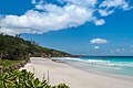
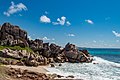
- beaches

Petite Anse Cocos beach on La Digue

Anse Patates Cocos beach on La Digue island
Petite Anse beach on La Digue island
The Grand L'Anse beach on La Digue island, Seychelles

Grand Anse beach

Anse Source d'Argent beach

Anse Marron beach

Anse Source d'Argent beach on La Digue
.jpg)
.jpg)
.jpg)
.jpg)


.jpg)
history

The island was discovered by Lazare Picault in 1744 and initially called Isle Rouge (red island). During the exploration of the archipelago by Marion Dufresne , the island was renamed "La Digue" after one of his ships. On February 12, 1771, Charles Oger, officer of the ship Heure du Berger , officially took possession of the island for the French crown. When the Seychelles were first conquered by the British in 1794, La Digue was uninhabited. The first settlers were insurgents deported from Réunion in 1798, including Maximilien Morel, whose wife Marie-Célérine Payet with five children and four slaves also resettled to La Digue in 1799. Although slavery was abolished in the French colonies in 1794, it continued to be practiced in the Seychelles. In 1815, after Maximilien Morel and his wife died, the Morel family owned 108 acres, about one-fifth the size of the island and 25 slaves. The names Morel and Payet can still be found frequently in the Seychelles today. In 1817 only 71 people lived on La Digue. In 1827 there were already 364 inhabitants, 240 of them slaves. On February 1, 1835, slavery was officially abolished. The former slaves, however, had to continue to work as workers on the plantations for low wages. It was not until February 11, 1839, that the age of slavery finally became a thing of the past in the Seychelles.
Economy and Infrastructure
Shipbuilding, fishing, vanilla cultivation and copra extraction and processing were traditionally the main sources of income on the island. In 1976 there were still no paved roads and only one hotel. Today tourism is another important industry. In contrast to Mahé and Praslin, there are no large hotel complexes on La Digue, but there is a wide range of guest houses and self-catering accommodation. The island has only a few kilometers of paved roads. There have only been a large number of cars on the island for a few years. The main means of transport is the bicycle and less and less the traditional ox cart.
La Digue has a school, a kindergarten, a church, a police station and a small hospital. The island has a helicopter landing pad and can be reached several times a day by ferry from Praslin .
Attractions

- La Digue Veuve Réserve bird sanctuary , breeding area for the Seychelles Paradise Flycatcher
- Dream beaches Pointe Source d'Argent and Anse Source à Jean with granite rocks and crystal clear water
- National Monument L'Union Estate Plantage, with u. a. historical settler house, copra mill, shipyard, turtle enclosure
- Grand 'Anse , spectacular beach in the southeast
- Neighboring islands Félicité and Coco Island for diving and snorkeling
- Silicate karst in the granite on Source d'Argent beach
literature
- Julien Durup: Histoire de La Digue . Océan Éditions, Saint-André La Réunion 2009, ISBN 978-2916-533-872 .
Web links
Individual evidence
- ^ Republic of Seychelles: Statistical Abstract . National Statistics Bureau, Victoria 2008. p. 1
- ↑ Food and Agriculture Organization of the United Nation (Ed.): Irrigation in Africa in Figures . Food & Agriculture Org., Rome 1995, ISBN 978-92-5003727-1 , pp. 257–259 ( preview in Google Book Search).
- ↑ Antoine Marrier Unienville (baron d '.): Statistique de l'Ile Maurice et ses dépendances, suivie d'une notice historique sur cette colonie et d'un essai sur l'ile de Madagascar . 1838, p. 204 ( preview in Google Book search).
- ^ Deryck Scarr: Seychelles Since 1770 History of a Slave and Post-slavery Society . C. Hurst & Co. Publishers, London 2000, ISBN 978-1-85065-363-9 , pp. 22 ( Preview in Google Book Search).
- ^ Edmund Burke: Dodsley's Annual Register . tape 58 . J. Dodsley, 1817, p. 623 ( preview in Google Book search).
- ^ Société de geographie (France): Bulletin de la Société de geographie . Societe de Géographie, 1827, p. 219 ( preview in Google Book search).