Lac Kénogami
| Lac Kénogami | |||||||||
|---|---|---|---|---|---|---|---|---|---|
|
|||||||||
|
|
|||||||||
| Coordinates | 48 ° 19 '36 " N , 71 ° 22' 34" W | ||||||||
| Data on the structure | |||||||||
| Construction time: | -1924 | ||||||||
| Data on the reservoir | |||||||||
| Water surface | 51.8 km² | ||||||||
| Reservoir length | 28 km | ||||||||
| Reservoir width | 6 km | ||||||||
| Maximum depth | 100 m | ||||||||
| Storage space | 631 million m³ | ||||||||
| Catchment area | 3 390 km² | ||||||||
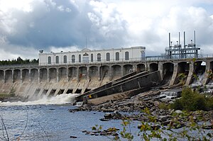
| Barrage de Portage-des-Roches | |||||||||
The Lac Kenogami is a reservoir in the Canadian province of Quebec .
Lac Kénogami is located 15 km southwest of Saguenay and on the northern edge of the Laurentine Mountains . It extends in an east-west direction over a length of 28 km, its width varies between one and six kilometers. It is the common lake of the separately dammed but closely spaced rivers Rivière aux Sables and Rivière Chicoutimi , created in 1924 . In a northern bulge are the Barrage Pibrac-Est and Barrage Pibrac-Ouest (Rivière aux Sables). and at the east end the Barrage de Portage-des-Roches (Rivière Chicoutimi). The water area is 51.8 km², the capacity 631 million m³. There are hydropower plants in the dams .
Other tributaries of Lac Kénogami are the Rivière Pikauba and Rivière Cyriac , which come from the south . The catchment area of Lac Kénogami covers 3390 km².


