
Lag Prau Pulté
| Lag Prau Pulté | ||
|---|---|---|

|
||
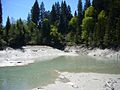
| Was Prau Pulté in autumn when the water level was falling | ||
| Geographical location | canton of Grisons | |
| Tributaries | underground | |
| Drain | above ground | |
| Data | ||
| Coordinates | 740 089 / 187800 | |
|
||
| Altitude above sea level | 1122 m above sea level M. | |
| surface | 1 ha | |
| length | 100 m | |
| width | 100 m | |
| Maximum depth | 6 m | |

The lag prau pulté is an almost circular lake a complex hydrological system in landslide -Schutt at Flims in the Swiss canton of Grisons . With a seasonally fluctuating level, it lies at an altitude of 1122 m (discharge).
phenomenology
The lake falls completely dry in autumn. Every early summer with the onset of snowmelt in the mountains, more water flows in the system and presses upwards at this point; however, the already existing water can completely disappear again in the event of a cold snap. Due to the air escaping from the submarine cave system, a bubbling can be observed all summer long on the constantly gray-brown, cloudy, loamy water. The overflowing stream feeds the Lag Prau Tuleritg, which also dries out in autumn, in an area chamber near Lake Cauma . This feeds the Cauma Lake, again using an underground route.
There are several groundwater systems in the Flims region. One of these has water outlets in Lag Tiert, in Lag Prau Pulté and in the Flims bypass tunnel, since a karst tube was cut when it was built. As a result of this cutting, the water pressure in the Karst decreased significantly, and noticeably less water escapes than before in Lag Tiert and Lag Prau Pulté. Since the Lag Prau Pulté feeds the groundwater body of Lake Cauma, this too is now lacking water. The missing water is to be supplemented with the feed system, which will go into operation from 2011.
Surname
The name designates the lake as the one near the meadow ( Prau ) with the name Pulté in the (former) neighborhood: Until the construction of the bypass road, the meadow Pulté was a quiet area chamber with paths in the hilly forest shaped by landslides, but was replaced by the Construction of the bypass road destroyed. Forest was cut down and the flat meadow running along the creek bed was filled up with an approximately 4 to 5 meter thick tunnel.
Location and surroundings
The lake is located in a basin west of the Films Waldhaus district and is completely surrounded by forest. Since the construction of the bypass road, it can be reached via a wide forest road or via a path over the former meadow, which, however, has to make the detour via the new tunnel exit. Another path leads over the ridge over the lake towards Runca.
Geologically, it lies in the debris of the Flims landslide . The other three Flims lakes are located in other depressions of this largely wooded, hilly terrain: Caumasee , Lag Prau Tuleritg and Crestasee .
Another lake, which filled with water before Lag Prau Pulté, lay under a curve in the cantonal road with coordinates 739.985 / 187.558. However, this was also destroyed or piled up during the construction of the bypass road. It is possible that the water system changed as a result, there are strong currents, especially on the southeast flank of the Lag Prau Pulté, which at least had not been noticed before.
Also destroyed during the construction of the bypass road were partially bricked, ancient cheese cellars, in which the farmers used to cool their cheeses. In summer, cold air penetrated from the underground, while in winter these holes remained noticeably snow-free - also because of the air escaping from the underground.
gallery

A lowering funnel in the lake bottom at Pentecost 2010; the lake had previously reached the line still visible halfway up the clay wall, but disappeared again during a cold weather period until Pentecost.
the first water in the almost empty clay hollow of the lake in spring
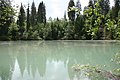
filled lake in May 2009


use
You cannot swim in the lake or it is not very inviting. In the Romance language, the word pult means a broth. When the lake is full, you may get stuck in the clay at the inevitable shallow edge. In 2015/2016, the measuring probe installed by the community disappeared in the clay.
Overflow data
Every year the municipality of Flims records the date of the first water overflow:
- 2010: May 28th
- 2009: May 15th
- 2008: May 17th
literature
- Hermann Anliker: Swiss homeland books: Flims ; Haupt-Verlag, Bern 1961
- Sina Semadeni-Bezzola: Waldhaus Flims , Werner Classen-Verlag, Zurich 1976
- Emil Kirchen: When the mountain falls: the landslide area between Chur and Ilanz - Chur [etc.]: Terra Grischuna , cop. 1993. [000943845] ISBN 3-7298-1087-1
- Municipality of Flims and Swiss Institute for Speleology and Karst Research: Waterways in the municipality of Flims and their influences on Lake Cauma. Public report. 2004-2008. ( PDF , 24 pages)
Web links
- Was Prau Pulté on schweizersee.ch
Individual evidence
- ↑ Breymann, Köppel: The suffix-containing Romanic field names Graubünden A Deichert'sche Verlagsbuchhandlung Nachf (Georg Böhme) - Leipzig and Erlangen 1894.