
Cauma lake
| Lag la Cauma | ||
|---|---|---|

|
||
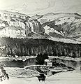
| Lake Cauma in August 2012 | ||
| Geographical location | canton of Grisons | |
| Tributaries | underground | |
| Drain | underground | |
| Islands | Isla | |
| Location close to the shore | Flims | |
| Data | ||
| Coordinates | 741 712 / 187 135 | |
|
||
| Altitude above sea level | 997 m above sea level M. | |
| surface | 10 ha | |
| length | 600 m | |
| width | 300 m | |
| Maximum depth | 30 m | |

Lake Cauma ( Rhaeto-Romanic Lag la Cauma , sometimes Lai da Cauma ) is located in the uninhabited southern part of the municipality of Flims in the Swiss canton of Graubünden . With a seasonally fluctuating level, it is located at around 997 m above sea level and is accessed with a specially built funicular .
Surname
The meaning of the name is derived from the Greco-Latin cauma , which means something like 'heat of the sun'. In Romansh it also refers to the resting place of the cattle over midday, i.e. when the sun is hot. However, the word also has the meaning of 'sleeping place'. “Caumasee” can best be translated as “lake of noon rest”.
Location and surroundings
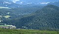
The lake is completely surrounded by forest. It is located in a depression south of Flims, about a hundred meters higher, in the Flims Forest , which separates the Grisons Surselva as the "area above the forest". The lake can only be reached on foot or by bicycle - the only driving ban in the Grosswald applies to bicycles on the main path, which leads directly from Flims Waldhaus to the funicular.
Geologically, it lies in the debris of the Flims landslide . The other three Flims lakes are located in other depressions of this largely forested, hilly terrain: Lag Prau Pulté , Lag Prau Tuleritg , and Crestasee . Southwest of Lake Cauma lies the highest hill in the lake region, the La Mutta hill ( 1236 m ). Almost in the middle of the lake is an approximately 3000 square meter, partly wooded island, which is known as Isla .
particularities
The water of Lake Cauma is strikingly turquoise green. It is also noteworthy that the westernmost bay of the lake does not freeze over in winter despite its height above sea level and the position of the lake in a cold air lake ; the reason can be assumed that the lake is traversed by powerful underground springs, which obviously have their origin in this part of the lake. The drainage is also underground. The water level is subject to considerable fluctuations, in 2015 the lake rose by at least 4 meters and 30 centimeters. The lake reaches its peak in mid / late July, which roughly corresponds to the end of the snowmelt in the surrounding mountains. In August the lake level will fall again, the rate of descent can reach a good five centimeters per day. However, the lake only reaches its lowest level after the winter snow has melted away in spring, towards the end of April. In previous years, attempts were made to determine the path of the water with elaborate dyeing experiments, but this did not succeed.
use

The lake is a popular seaside resort in summer; in its sheltered hollow it reaches a water temperature of up to 24 degrees. The lake has comparatively high temperatures, especially in early summer, due to the lower volume on the still low water level and the underground feed. The western bay remains ice-free all winter even in the longest cold spells.
Since 1937 a 125 meter long funicular has been leading down to the lake, which was renewed on the old route in 1999 . The Caumasee lift is in operation during the summer season and is free to use. During the bathing season, if the weather is reasonably good, an entrance fee is charged in the infrastructure area. Over 3000 admissions are counted on peak days. The restaurant is closed in winter; however, the lake can be reached and circumnavigated on cleared footpaths.
history

Early on, but certainly in the 19th century, the water of Lake Cauma was considered medicinal. The sick came to use its water to cure eye and skin ailments, gout and unhealed wounds. In 1835 a bathing hut was built on the northeast bank; a pumping station drove Lake Cauma water into three bathing basins and a communal tub, which, however, disintegrated after a few years.
The island in the lake then belonged to a Flimser who had received it as a reward for special services. He built a restaurant on it, but it could not hold up and was removed again by the «Kur- und Seebadanstalt Waldhaus» company founded in 1875. The company received the concession from the community for the sole management of Lake Cauma, with the condition that the necessary driving and hiking trails be created.
Around 1880 hiking trails were laid out around Lake Cauma; Rowing boats were bought and a boathouse and a first bathing establishment were built. In 1884 the island became the property of the Hotel Waldhaus . In 1906, the first bathing establishment was replaced by a new chalet-style building with two non-swimmer pools separated by sex and numerous changing rooms. Because of the strongly fluctuating water level in the lake, the building was equipped with two floating bodies and, depending on the water level, rose and fell on the brick foundations at the end of the season. The building stood on these areas all winter. In 1911 a second floor was added to the building and a restaurant was added. Two small bays in the western part and a section in the eastern part were later paved with stone slabs and cleaned annually in spring until they were taken over by the community, so that a comfortable entry into the lake was possible. One of the slab systems is a non-swimmer pool with a seating edge. Unfortunately, the lake has not reached this normal summer level in recent times, see Problems with the water level . Even earlier, water levels had in some cases been lower than desired; Hotel director Bezzola had one of the irrigation streams in the Flims Forest extended to above the Prau-Pulté-See , where it cascaded to the lake and below the small bridge on the west side, around the outflow of the Prau-Pulté - Strengthening lakes, in the hope of supporting the level of Lake Cauma.
In 1969, Lake Cauma and all its facilities were bought back by the community for half a million francs. The aging swimming pool was demolished and replaced by new buildings on land. In particular, a pumping station was built to transport the wastewater into the Flims sewer system and into the sewage treatment plant. Remnants of the old infrastructure are the restaurant's terrace and the masonry entry areas, which ensure good access to the water even when the water level drops in August. In the 1980s, wide steps were built for the triathlon . In addition, a wild, inaccessible bay in the eastern part was filled in to gain additional space for a lawn.
On June 2, 2003, the new building project “Fels” by the Flims architect Valerio Olgiati was rejected by those entitled to vote with 1007 to 267 votes. A later reduced project was also rejected. The building blocks in the “provisional style” that were built up until 1972 were then partly torn down in 2005 and partly beautified on the outside. A children's pool from the 1980s was also demolished and replaced by a children's water playground, and a beach volleyball field was also created. At the beginning of December 2019, a building loan for a new restaurant was rejected again. Corinna Menn's project included a wooden house with a full service restaurant on the first floor.
first inn on the island, 1880

Seebad Caumasee 1880
1911

Bathing operation around 1915

This is a model of the floating bathing establishment, originally built in 1911 on a single storey and later extended


gallery
Location of Lake Cauma
in the landslide area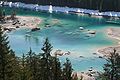
Low water level in April 2007

View from the south

restaurant


fauna

In the Cauma lake, fish live in sizes ranging from minnow (also called "Bammeli" or "Bambeli" in Switzerland) to full-grown carp around 50 centimeters long. This is why gray herons occasionally come to visit, but they feel disturbed by the bathing activity. The wagtails are a little less likely to be disturbed, at least one pair has already nested several times in the “stone”, the large boulder that carries the flag and is the target of countless swimmers, which leads to long feeding breaks.
A special feature were the eels that were released in the lake by Captain Meyer around 1882. He had also put animals in the Heidsee and the no longer existing monastery pond near Churwalden. Only in Lake Cauma did the animals survive. In 1894 they were examined and dissected by biologists (including Prof. Dr. Johannes Heuscher). Animals of both sexes were found. In 1932, Dr. Alberto Gandolfi found the animals examined by him 45 years old. But even in 1986 the lifeguard was sure to see a specimen. The year before, two divers wanted to investigate the presence of these animals again with the help of biologists, but despite the support of the Bündner Hunting and Fishing Inspector, the Naturschutzbund and the Bündner Naturmuseum, they did not receive a permit from the community.
In the 1970s, photographer Jules Geiger from Flims brought a pair of swans to the lake in the summer. The mallards, which have appeared since the late 1980s, do not like the rising water level of Lake Cauma when breeding. That is why there were duck families who took their chicks from the nearby Lag Prau Tuleritg with its almost constant water level by land to the larger Lake Cauma and thus accepted a dangerous hike through the forest. Previously unknown but the crabs that occur are more and more common. Presumably they are jackdaws , which are also found in the nearby Cresta Lake. Occasionally other birds come to visit; Seagulls can be seen again and again and from 2013 to 2019 little grebes were guests every year , but as shy wild animals in Lake Cauma they often feel disturbed by the many activities. One of three great egrets that appeared was also stubborn, staying loyal to the lake for weeks in 2013, even in the high season. A cormorant could also be seen in 2013 and 2017.
Problem with the water level from 2003
A noticeably low water level has been observed at Lake Cauma since 2003 : When the underground bypass of Flims was built, a large karst tube was cut so that over a thousand liters / second have been withdrawn from the Lag Tiert- Lag Prau Pulté karst system since 2002. Since this karst system feeds Lake Cauma via Lag Prau Pulté and Lag Prau Tuleritg, Lake Cauma itself also has less water available.
From 2002, the water level (measured by the scale on the large rock in front of the island) rose significantly less and hardly reached the average of 8 meters that was reached in the past twenty years before the tunnel was built. In a hydrogeological study by karst expert Pierre-Yves Jeannin in February 2009, the influence of tunnel construction on the water level of Lake Cauma was demonstrated. The general drought of recent years also played a role.
The water level has been increased since 2011 by adding up to 700,000 cubic meters of additional water a year to the Pultébach , which mainly feeds Lake Cauma via seepage sources. Water is taken from the Platt-Alva-Bach and the Flembach for six to eight weeks a year and fed to the Pultébach , which indirectly feeds Lake Cauma. This is intended to raise the lake level by half a meter to one meter. If tunnel water were discharged directly into the lake, the water would lose its characteristic turquoise color. A popular initiative that demanded this was withdrawn. Objections from environmental organizations were withdrawn after a positive assessment of the project by expert Simon Löw from ETH Zurich and the project was implemented.
Individual evidence
- ^ Ruinaulta (magazine) , September 9, 2016, page 2
- ↑ Waldhaus Flims ( Memento of the original dated September 23, 2016 in the Internet Archive ) Info: The archive link was inserted automatically and has not yet been checked. Please check the original and archive link according to the instructions and then remove this notice.
- ↑ Valerio Olgiati's project for a restaurant on Lake Cauma: Ephemeral and sublime . In: Neue Zürcher Zeitung . May 5, 2002 ( nzz.ch ).
- ↑ Valerio Olgiati: Das Caumaseeprojekt , magazine for landscape architecture, volume 40 (2001)
- ↑ Sina Semadeni-Bezzola: Waldhaus Flims. Werner Classen-Verlag, Zurich 1976.
- ↑ Message on building loan for the replacement of the restaurant on Lake Cauma ( Memento from December 27, 2019 in the Internet Archive ), Flims municipality, November 5, 2019
- ↑ No new restaurant on Lake Cauma , southeastern Switzerland (newspaper) , December 8, 2019
- ↑ Charly Bieler : The secret of the eels in the Caumasee , Bündner Anzeiger, December 6, 2006. P. 24/25
- ↑ Waterways of the municipality of Flims and their influences on Lake Cauma. (PDF) at gemeindeflims.ch.
- ↑ Switzerland Current. from February 17, 2009, articles in Southeastern Switzerland from February 17 and 18, 2009.
- ↑ The Caumasee water procurement project can be implemented - media release from the Canton of Graubünden. dated April 6, 2010.
literature
- Hermann Anliker: Flims . In: Swiss home books . tape 106-108 . Haupt, Bern 1961, DNB 450091937 .
- Sina Semadeni-Bezzola: Waldhaus Flims. History and stories of a spa hotel . Werner Classen, Zurich 1976, ISBN 3-7172-0229-4 .
- Emil Kirchen: When the mountain falls. The landslide area between Chur and Ilanz . Terra Grischuna, Chur, ISBN 3-7298-1087-1 (around 1993).
- Philipp Häuselmann, Pierre-Yves Jeannin: Waterways in the municipality of Flims and their influences on Lake Cauma. Public report. 2004-2008 . Ed .: Swiss Institute for Speleology and Karst Research, Municipality of Flims. La Chaux-de-Fonds January 27, 2009 ( gemeindeflims.ch [PDF; accessed October 6, 2011]).