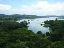
Laguna de Metapán
| Laguna de Metapán | ||
|---|---|---|

|
||
| Geographical location | El Salvador | |
| Tributaries | Groundwater and rainwater | |
| Drain | Río San José | |
| Location close to the shore | Metapán | |
| Data | ||
| Coordinates | 14 ° 18 '43 " N , 89 ° 27' 58" W | |
|
|
||
| Altitude above sea level | 406 m | |
| surface | 16 km² | |
| Maximum depth | 6 m | |
Laguna de Metapán is a freshwater lake in the Santa Ana department of El Salvador .
The lake covers an area of 16 km² in the rainy season and around 14 km² in the dry season . The average depth during the highest rainfall is 6 meters and the water level changes by around 2 meters in the dry season. In the middle is a small island popularly known as Peñita. Laguna de Metapán is of volcanic origin and is nestled in a valley, surrounded by lava rock, small volcanoes and has a direct connection to Lago de Güija .
The bordering Bosque la Barra wetland, with a total area of around 10 hectares with mangrove forests, is home to numerous threatened animal and plant species.
