Lakeview Gusher
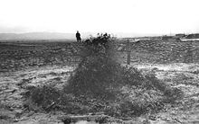
Known as the Lakeview Gusher Number One , the largest registered blowout ("gusher") in the history of oil production in the United States is known. In 1910 an estimated 1,400,000 m³ (1,230,000 tons) of crude oil poured out.
The location of the accident is about half a mile east of the Taft - Maricopa Highway on California State Route 33 in the Midway Sunset Oil Field in Kern County , about 25 miles southwest of Bakersfield , California .
Today there is a memorial stone with a bronze plaque ("California Historical Landmark number 485") at the scene of the event.
background
The Lakeview Oil Company began drilling the Lakeview Number One well on January 1, 1909. In the course of the drilling, only natural gas was initially found. Lakeview entered into a partnership with the Union Oil Company at the time , which wanted to build storage tanks on the site.
The blowout began on March 14, 1910 when the well reached a depth of 740 meters. The drilling technology of the early 20th century was not yet familiar with safety devices such as blowout preventers , which in modern drilling can in most cases prevent a blowout. As a result, the drilling equipment could not withstand the high pressure in the Lakeview well and large quantities of petroleum leaked out.
The casing of the borehole consisted of steel pipes that were used both to guide the drill and later to pump out the oil. The pressure of the blowout caused some of the casing to be ejected from the wellbore. As a result of the eruption, about 1,400,000 m³ (9,000,000 barrels ) of oil flowed out of the well until the eruption was finally brought under control after 18 months in September 1911.
The initial daily outflow rate was 2,990 m³ (18,800 barrels) and peaked at around 14,000 m³ (90,000 barrels). This created a flow of crude oil that sprang from the source until the outflow could be contained by oilfield workers with dams and dikes made of sandbags. The spring did not catch fire during the 18-month blowout period.
Individual evidence
- ^ Richard C. Bailey: Kern County Place Names. Merchant's Printing and Lithography Co, Bakersfield 1967.
- ↑ William Rintoul: spud. In: Recollections of Pioneer Days in the California Oil Fields. California Historical Society, San Francisco 1976, ISBN 0910312370 , pp. 106-113.
- ^ William Rintoul, Susan F. Hodgson: Drilling through time: 75 years with California's Division of Oil and Gas. California Department of Conservation, Division of Oil and Gas, Sacramento 1990, ISBN 096271240X , pp. 13-15.
- ^ FF Latta: Chapter 33. In: Black Gold in the San Joaquin. Caxton Printers, Caldwell, Idaho 1949.
Web links
- San Joaquin Geological Society article on the gusher.
- UC Berkeley archival photograph of the gusher on "day 34." ( Memento of March 29, 2008 in the Internet Archive )
- The Lakeview Gusher site image at The Center for Land Use Interpretation
- Geological finds from the region and photos of the landscape on the website of the American geologist Andrew Alden.
Coordinates: 35 ° 5 ′ 29.1 ″ N , 119 ° 24 ′ 5 ″ W.


