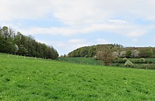
Barmerfeld landscape protection area
The Barmerfeld landscape protection area with an area of 77.96 hectares is located in the area of the independent city of Hagen in North Rhine-Westphalia . The landscape protection area was designated in 1994 with the landscape plan of the city of Hagen by the city council of Hagen. Residential and commercial areas newly designated in the future in the Hammacher and Barmerfeld areas can be excluded from landscape protection through a legally binding development plan and lose their protection status.
description
The LSG borders directly on the A 46 in the north . The Herbeck landscape protection area is located north of the A 46 . The Hagen motorway junction forms the border in the west, and the protected area extends to the B 7 in the south . South of the B 7 is the Hassley landscape protection area and in the southeast the Temporary Mastberg nature reserve and the Mastberg and Weißenstein nature reserve . Two smaller parts of the Barmerfeld nature reserve border the two nature reserves south of the B 7 like peninsulas. The Lenne-Niederung nature reserve joins in the east .
In the LSG there are agriculturally used areas with fields and grassland, which are structured by distinctive sieves and hedge structures. Forest areas with the valuable beech wood neck also belong to the LSG. The former Ewiges Tal landfill is located to the west of the LSG . In the east of the LSG there is a sewage sludge dump on the clarification basin of the former Hohenlimburg sewage treatment plant.
Protection purpose
According to the landscape plan, the designation took place "because of the diversity, uniqueness and beauty of this landscape characterized by arable and grassland complexes".
See also
Web links
literature
- City of Hagen: Landscape plan of the city of Hagen. Hagen 1994
Individual evidence
- ↑ a b landscape plan of the city of Hagen. (PDF) In: hagen.de. December 1994, pp. 237–291 , accessed on April 29, 2018 (updated 2010).
Coordinates: 51 ° 21 '59 " N , 7 ° 32' 5.4" E
