
Lassallestrasse (Munich)
| Lassallestrasse | |
|---|---|
|
|
|
 |
|
| Lassallestrasse next to the Eggarten housing estate with a view of the Uptown Munich skyscraper | |
| Basic data | |
| State capital | Munich |
| Borough |
Moosach Feldmoching |
| Hist. Names | Aufhüttenstrasse |
| Name received | 1963 |
| Cross streets | Wilhelmine-Reichard-Strasse, Franz-Fackler-Strasse |
| Numbering system | Orientation numbering |
| Buildings | Capernaum Church |
| use | |
| User groups | Pedestrian traffic , bicycle traffic , car traffic , public transport |
| Technical specifications | |
| Street length | 1 km |
The Lassallestraße is a 1 km long city road from Munich city district Moosach in the settlement on Lerchenauer lake in the district Feldmoching-Hasenbergl . It is the extension of Hanauer Strasse and leads from Triebstrasse to Franz-Fackler-Strasse.
description
The Eggarten settlement , the Kapernaum church and the Lerchenauer lake are located on it . The six-lane road at the beginning becomes two-lane before crossing under the Munich North Ring .
It was named in 1963 after the socialist politician Ferdinand Lassalle . The road was before renaming under the name Aufhüttenstraße known
For the 1972 Summer Olympics (for a better connection between the Olympic Park and the Oberschleißheim regatta course ) in Munich, Lassallestrasse was led by a road bridge over the railroad tracks to Lerchenauer Strasse , but was then located at Franz-Fackler-Strasse (at today's "Lassallestrasse-Platz ") Dissolved.

View from the railway bridge to the north
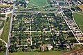
Aerial view of the Eggarten settlement, Lassallestrasse on the left

Northern end with transition to Franz-Fackler-Straße

Meadow biotope in the southwest


Individual evidence
- ↑ stadt Bezirk24.de - street names
- ↑ "In 1939 the entire forest of the former Upper Pheasant Garden between the Munich Landshut railway line and Aufhüttenstraße (today Lassallestraße ) had to give way to the embankment for the planned marshalling yard in Munich-North." From Volker D. Laturell and Georg Mooseder: The Hunt in the North of Munich zeitschrift-amperland.de
Coordinates: 48 ° 11 ′ 43 ″ N , 11 ° 32 ′ 5 ″ E