Le Clos du Valle
| Le Clos du Valle | ||
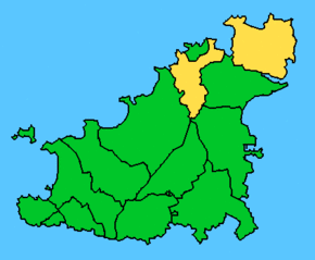
 Le Clos du Valle is the larger eastern part of the two parts of Vale (yellow) |
||
| Geographical location | ||
|
|
||
| Coordinates | 49 ° 29 '59 " N , 2 ° 30' 50" W | |
| Waters 1 | English Channel | |
| length | 4.3 km | |
| width | 3.2 km | |
| surface | 7 km² | |
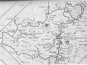
 On the French map from 1757, Le Clos du Valle can still be clearly recognized as an island. |
||
Le Clos du Valle is a peninsula that forms the northeast of the Channel Island of Guernsey . Until 1806, Le Clos du Valle was a tidal island , which was separated from the actual island of Guernsey by the tidal channel La Braye du Valle . This tidal creek was filled in by the British government in 1806 for defense purposes (against France), making the tidal island a peninsula. The peninsula forms the greater part of the two parts of the municipality ( parish ) Vale . The smaller part of the municipality southwest of the peninsula consists of the districts of Pleinhaume and Vingtaine de l'Epine , while Le Clos du Valle is divided into L'Ancresse Common and Bordeaux . The two parts of the area are separated from each other by the area of the municipality of Saint Sampson , the northern border of which forms the former La Braye du Valle .
The peninsula is a maximum of 4.3 km wide, but at its narrowest point, the former course of La Braye du Valle , only 2.1 km. The length is 3.2 km and the area around seven square kilometers.
Individual evidence
- ↑ Paddy Dillon: Channel Island Walks. Cicerone Press, Milnthorpe, Cumbria, UK 1999, ISBN 1-85284-288-1 , p. 169.
- ↑ A Guide to Vale.
- ↑ Sir Edgar MacCullogh, Edith Frances Carey: Guernsey Folk Lore, a collection of popular superstitions, legendary tales, peculiar customs, proverbs, weather sayings, etc., of the people of that island. E. Stock, London 1903, p. 183.
