Lemo (Indonesia)
| Lemo | ||
|---|---|---|
|
|
||
| Coordinates | 3 ° 3 ′ S , 119 ° 53 ′ E | |
| Basic data | ||
| Country | Indonesia | |
|
Geographical unit |
Sulawesi | |
| province | Sulawesi Selatan | |
| ISO 3166-2 | ID-SN | |
| Kabupaten | North Toraya | |
|
?
|
||
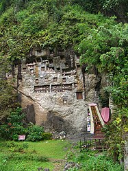
Lemo is a Toraja village in the Makale Utara District ( Kecamatan ) in the Toraja Utara District ( Kabupaten ) , Sulawesi Selatan Province , Indonesia , about eleven kilometers south of Rantepao and seven kilometers north of Makale . The name Lemo means lemon because of the shape of the hills near the village.
The village with four rice storage tanks and a Tongkonan is because of the nearby rocky graves with galleries of tau-tau -Ahnenfiguren one of the major tourist attractions in Toraja . Unlike in nearby Londa , there are no tombs at the foot of the rock for the common people. Lemo is one of ten traditional Toraja settlements put on the "Tentative List" by the Indonesian Ministry of Culture for nominations by UNESCO .
Individual evidence
- ↑ United Nations Educational, Scientific and Cultural Organization (UNESCO): Tana Toraja Traditional Settlement. Retrieved March 21, 2014 .

