
La Corbière lighthouse
| La Corbière lighthouse | ||
|---|---|---|
 |
||
| Place: | St. Brélade , Jersey , Channel Islands | |
| Location: | jersey | |
| Geographical location: | 49 ° 10 '47.4 " N , 2 ° 15' 0.4" W | |
| Fire carrier height : | 62 ft (18.9 m ) | |
| Fire height : | 119 ft (36.3 m ) | |
|
||
| Identifier : | Iso.WR.10s | |
| Scope knows: | 18 nm (33.3 km ) | |
| Scope red: | 16 nm (29.6 km ) | |
| Operating mode: | electric, automatic since 1976 | |
| Function: | Lighthouse , fog horn, visual navigation sign | |
| Construction time: | 1873 | |
| Operating time: | since April 1874 | |
| International ordinal number: | A 1620 | |


The La Corbière lighthouse is one of the most important landmarks on the Channel Island of Jersey . It is located on a tidal island off the coastline and belongs to the municipality of St. Brélade . It was named after the surrounding rocky and sparsely inhabited coastal landscape of La Corbière .
Building and function
The rocks reaching far into the open sea and the extreme fluctuations in the tide make seafaring in this area of the island of Jersey extremely treacherous. Numerous shipwrecks in this area testify to this. Nevertheless, it was not until the 1860s that a lighthouse came into discussion at this point. Finally, a tidal island about 500 meters off the coast, which can only be reached on foot at low tide, was chosen to erect this navigation sign.
The civil engineer Sir John Coode (1816–1892), who together with him created the world's first concrete lighthouse , was commissioned with the planning . From the outset, this was intended for electrical operation. It was completed in November 1873 and began operations in April 1874. A concrete access road to this island was built in the 1930s. In 1976 the beacon was switched to automatic operation, the lighthouse has been uninhabited and unoccupied since then.
With its shape and its white paintwork, it quickly became a symbol of the island and is depicted on both the 5-pound banknote and the 20-pence piece.
Despite its reliable function, ship accidents in this area cannot be ruled out. The last one was in 1995 when the French catamaran St. Malo hit the ground , a memorial on the coast commemorates this and the subsequent rescue of all passengers.
Landscape of La Corbière

La Corbière ( Jèrriais : La Corbiéthe ) is the most south-westerly area of the island. Historically, this term comes from a place where crows nest (crows: old: corbîn ). The crows have long been supplanted by the omnipresent seagulls .
The frequently storm-tossed place, which also has no trees, is ideal for views over the sea. A 7-storey observation tower (now known as the MP2 Tower ) from the time of the German occupation of Jersey 1940–1945 heralds this advantage ; this was then used to monitor radio traffic in the English Channel until the 1970s .
Photo gallery

La Corbière lighthouse when a storm is coming
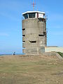
MP2 tower in La Corbière
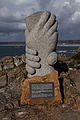
Monument to the misfortune of St. Malo


.JPG)
literature
- Keith E. Morgan: South Jersey - Through the Time . Amberhill Publishing, Cloucestershire 2012, ISBN 978-1-4456-0621-7 .
Web links
- Russ Rowlett: Lighthouses of Jersey ( English ) In: The Lighthouse Directory . University of North Carolina at Chapel Hill . Retrieved October 8, 2017.
- Entry in the list in the ARLHS World List of Lights