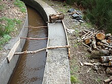
Levada
Levadas are artificial watercourses on the Portuguese island of Madeira , with which water is directed from the areas with higher rainfall in the north and in the center of the island to the agricultural cultivation areas in the south. Since some large stretches have to be overcome, most of the levadas have only a very slight gradient. To do this, these waterways overcome valleys and mountains, cross tunnels , cross natural watercourses and also lead over bridges.
Today the levadas are mainly used for tourism in addition to transporting water . Hiking trails are signposted in many places along the paths that run alongside the water .
Geographical requirement for the construction of the levadas
The island of Madeira is divided into a south and a north half by a mountain range that extends from east to west. For the eastern part of the mountain range it is characteristic that the mountain range slopes much more sharply to the north than to the south and forms a natural barrier against the north and northeast winds. This mountain area therefore records increased rainfall - up to 2000 mm annually, without a pronounced dry season - while the south of the island can be dry for six months (semi-arid). Reduced hours of sunshine and lower temperatures also reduce evaporation on the north side of the island. These factors cause a great abundance of water in the north. Because of the extremely steep terrain, this wealth cannot be used for agriculture there. On the dry south side with its gently sloping slopes, on the other hand, there are many more cultivation areas. The water is therefore abundantly available where it cannot be used accordingly. A geological condition intensifies this effect. Madeira's geological structure shows various inclined layers of lava , slag , tuff and ash, which are separated from one another by non-porous basal reefs and conglomerate masses . The rain that seeps through the surface onto these embeddings seeks the steepest path to the drain. Even precipitation that rains down on the southern slopes mostly drains to the north. Most of these springs emerge at an altitude of 1500 to 1600 m. The problem of how to bring the plentiful water supplies (it is assumed that 200 million m³ of stored water in the porous layers) of the north to the south can be solved by the construction of the levadas. Today practically every field on the island is irrigated by levadas in the dry season, from April to October.
The history of the levadas
The first irrigation canals were built on Madeira as early as the 15th century. In 1461, only 40 years after the island was settled, Prince Ferdinando decided that two men - the Hereus - should be tasked with distributing the water. In 1485, King John II decreed when the levada officers should distribute the important liquid to the users. In 1493 he passed a law according to which no landowner was allowed to obstruct the construction, repair or use of levadas. From 1650 onwards , larger and wider canals were created for the rapidly increasing consumption, especially for sugar cane cultivation and water mills . Arab and African slaves had to do the often breakneck work at dizzying heights. The skill of the Moors , who had great experience in irrigation technology, probably contributed a lot to the construction of the canals. As a result of the stagnating sugar trade , there are hardly any reports of any further expansion of the levadas after 1680.
The levada system today
If you ask about the extent of the irrigation system, you can hear numbers from 800 to 5000 km, depending on whether the small branches of the large channels that reach each field are counted or not. The youngest and most modern levada in Madeira is the Levada dos Tornos , which opened in 1966 . It has a length of 106 km and irrigates 9900 hectares of land. 16 km long it leads through tunnels, the longest of which is 5.1 km. An electricity company is integrated into this levada. A total of three power plants are operated with the water from levadas before the water is used for the actual purpose of irrigation. Since the water must always flow evenly, the levadas must be constantly maintained. Therefore, all levadas are accessible, either on a levada wall or a path next to the canal, the Passeio da levada . At altitudes up to 700 m, these paths serve the residents as footpaths to their houses. In wash houses, the water for the troughs is drained, children bathe in the levada and occasionally the levada is used as a transport route, e.g. for wood.


