Lewthwaite Strait
| Lewthwaite Strait | ||
|---|---|---|
| Connects waters | Scotia Lake | |
| with water | Weddell Sea | |
| Separates land mass | Coronation Island | |
| of land mass | Powell Island | |
| Data | ||
| Geographical location | 60 ° 40 ′ 59 ″ S , 45 ° 6 ′ 58 ″ W | |
|
|
||
| Smallest width | 4 km | |
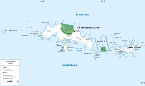
| Map of the South Orkney Islands with the Lewthwaite Strait | ||
The Lewthwaite Strait is a 4 km wide strait in the archipelago of the South Orkney Islands . It runs between Coronation Island in the west and Powell Island in the east.
The American sealer captain Nathaniel Palmer and his British counterpart George Powell discovered the sea route in December 1821 while exploring the South Orkney Islands together. It is named after John Lewthwaite, a navigational teacher from London, to whom Powell had given his map and his expedition journal.
Web links
- Lewthwaite Strait in the Geographic Names Information System of the United States Geological Survey (English)
- Lewthwaite Strait on geographic.org (English)

