Lieps (island)
| Lieps | ||
|---|---|---|
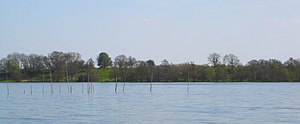
| Lieps Island in Lake Schwerin from the west | ||
| Waters | schweriner Lake | |
| Geographical location | 53 ° 44 '53 " N , 11 ° 27' 36" E | |
|
|
||
| length | 1.5 km | |
| width | 600 m | |
| Residents | uninhabited | |
| Location of the island of Lieps in Lake Schwerin | ||
The island of Lieps is located in the northern third of the Schwerin outer lake in Mecklenburg-Western Pomerania . Territorially, it belongs to the municipality of Bad Kleinen .
It is about 1.5 kilometers long and at its widest point it measures around 600 meters. The island got its shape during the last glaciation in the Ice Age about 15,600 years ago. The name of the island comes from the Slavic Lipa = linden tree . Around 1700 the until then forested island was cleared and after being leased in 1758 it was used completely for agriculture. The tenant built a farm with cattle pasture on the plateau. Grain, fodder beet and potatoes were grown. This agricultural use ended in 1956 when the farm was completely destroyed by lightning. Since then, the island has been used exclusively as a summer pasture for cattle.
It is a popular destination for water sports enthusiasts in summer . The bank and the slope to the plateau are wooded. Many rare bird species are native to the island. There is no tourist infrastructure. The island can only be reached by ship or boat.
To the west of the island of Lieps, separated by a narrow channel, is the island of Horst .


