Lieps (sandbar)
| Lieps | ||
|---|---|---|
| Sandbank Lieps in the Wismar Bay | ||
| Waters | Baltic Sea | |
| Geographical location | 53 ° 59 '34 " N , 11 ° 17' 16" E | |
|
|
||
| length | 3.5 km | |
| width | 2.5 km | |
| surface | 9 km² | |
| Mecklenburg in 1614 with the Wismar Bay, with the Lieps sandbank in the northwest (top left) | ||
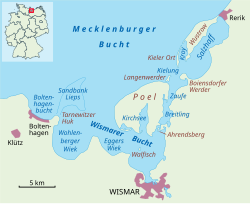
The Lieps is a sometimes dry sandbank northwest of Wismar and five kilometers west of the island of Poel , which extends from the Tarnewitzer Huk 3½ kilometers to the east, with a width of up to 3½ kilometers. The name is probably derived from the Slavic word lipa for linden tree , which suggests that the island was forested at the time.
In the Middle Ages , the Lieps was a peninsula that bounded the Wohlenberger Wiek in the north. Later storm floods probably severed the land connection. The Lieps became known as the location of the first German lighthouse . It was mentioned in a document as insula Lypec in 1266. At the end of the 19th century, the island extended several hundred meters in an east-west direction. Since the middle of the 20th century, the Lieps has not been listed as an island on land and sea maps.
On January 14, 2006, a fisherman discovered a 17-meter-long and approximately 20-ton dead fin whale on the Lieps , which had got lost in the Baltic Sea .
Web links
- Overview page for shoal maps, one of them for the location of Lieps
- Information on the location of former islands in the North and Baltic Seas - private website


